Update Sept. 21, 2014
Download Version 1 here: http://www.mission4today.com/index.php?name=Downloads3&file=details&id=2041Hengyang V1As of this first version right now, there are very few static objects. I have placed airfields, bridges, roads and railways, some railroad stations and factories. I will let others, mainly Riptide_One, to do the rest of the populating of cities. Mandrill is also helping to create new China houses. Some of the heights of the Map_H seem unreal but I did get the srtm's satellite data from agracier who was kind enough to help get me started. Many of the textures are from agracier, oknevas, and Mixx but have been tweaked to to go together in this map.
The map is playable now if anyone would like to start making missions and using this map. Airfield locations and static points will not change. I did not know what many of the airfields looked like during the war so I had to use my imagination. I welcome anyone who would like to change the airfield textures if that would improve things (Just be sure not to change waypoints, etc).
*Notes on airfields are included in the download.
A later Version 2 will be available in the future with populated cities and it will replace this Version 1.
--------------------------------------------------
Installation:
Paste the following line in your all.ini:
cztx_Hengyang cztx_Hengyang/load.ini
**************************************************************
2013...Thanks to agracier for lending the startup map, I have begun work on a region of China where the Flying Tigers and 14th Air Force saw most of their action.
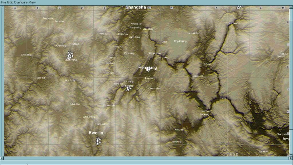
(screenshot does not show bottom edge of map)
The map is very mountainous and includes such famous places as Kweilin (present day Guilin), Lingling, Hengyang, Changsha, Chihkiang, and Canton. Some places may not be in their exact locations. Canton is close to the bottom edge of the map but I'll squeeze it in so as to make a base for three Japanese airfields there.
This map is much smaller than BurmaLower so it seems I can finish it faster (I'm guessing release time will be a year and ...two weeks haha!). I'm happy with texture combinations of mountains and hills so far. Still need city and more agricultural fields textures. Again, the DBW's Slot forest/3D trees is used because I think it's perfect!

Some airfield locations are started but still need to make textures for them. It's very difficult (in some places) to be able to get aircraft to land using 4.10 landing waypoints. A good example is Chihkiang where I had to move the whole location just to get fighters and B-25s to land between the mountains. The location is not exact but at least a major airfield is on the map. I'd also like to add a Japanese airfield near Nanching which is not on the map...it will not be an exact location but at least there will be a Japanese airfield in the northeast (representing attacks from Hankow or Nanching). Amoy is just off the map but I can add a small Japanese field nearby on the coastal plain.
I'd like to make a request for photos of airfields so that I can possibly make textures of. I should have enough texture lines for almost all airfields so that each a/f can have it's own unique look... but only if I can find photos of such airfields. I have a good PDF of Canton and its airfields which is excellent for research but I need more so if anyone has material they'd like to share then please do so.


 Author
Topic: South-central China WIP (Read 60926 times)
Author
Topic: South-central China WIP (Read 60926 times)