Special Aircraft Service

Please login or register.

Login with username, password and session length
Advanced search  
Pages: [1] 2 3 4 ... 10   Go Down

Author Topic: Map of Transcaucasia  (Read 22206 times)

0 Members and 3 Guests are viewing this topic.

Uzin

  • Modder
  • member
  • Offline Offline
  • Posts: 2816
  • On lifetime holidays
Map of Transcaucasia
« on: January 16, 2018, 07:37:58 AM »

Upon the initiative of zloy (aka nachprod) the work on the area situated south of CzechTexan's map of Caucasus, from Tbilisi on the north to Erbil in the south is starting.
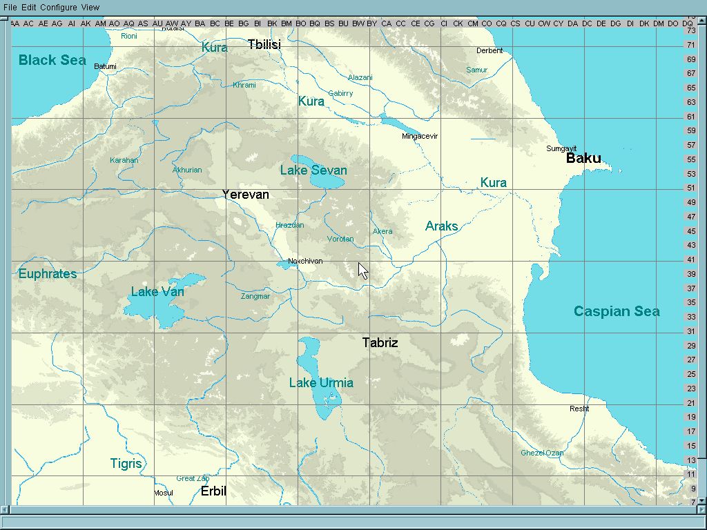


The area is very mountaineous , and moreover, it cotains large lakes positione far above the sea level.
In our beloved Il-2 Sturmovik, the rivers and lakes should be at sea level in order to allow both bridge positioning and ships traffic.
By bringing the lakes to sea level we are at risk to deform height map perhaps unacceptably,
while letting them at their narural height we must abandon the possibility of ship movement on them.
So I ask the community to help me what to decide of the two ways.
Any comments and proposals will be appreciated.


EDIT:
Final version of the three maps, covering WWI, WWII and era of concrete airfields,
can be d/l here :

https://www.mediafire.com/file/kf0ytgr2rnk06w5/Zakavkazye_map_I%252C_II%252C_III.7z/file

Credits:
zloy, Skyfan, Toobone, Lexsey, andrey65, deSAD, ZRN395, Mixx, Vasya, Molva, Grejf11,
farang65, Dimlee, RealDarko, carsmaster, vonofterdingen, bomberkiller, Maro,
CzechTexan, Kelso, Mission bug, David Prosser, BlackStaff, I hope nobody forgotten.
Logged

farang65

  • never two weeks two decades
  • SAS Team
  • member
  • Offline Offline
  • Posts: 2787
  • Fortress Formosa
Re: WIP map of Transcaucasia
« Reply #1 on: January 16, 2018, 07:48:09 PM »

Lakes above sea level looks really cool  ;D :D
I've had a number of lakes like this in other maps.
Really only for scenic purposes but gives a variety concerning water levels on maps
Have even had a lake in a really high volcano once.
Scenic or functionality your the mapper you choose.  ;D :D

Cheers,
Kirby
Logged

Uzin

  • Modder
  • member
  • Offline Offline
  • Posts: 2816
  • On lifetime holidays
Re: WIP map of Transcaucasia
« Reply #2 on: January 17, 2018, 04:58:05 AM »

Thank you, Kirby.
Perhaps you will be so kind and give me advice how to prevent creating "caves" at the river banks?
I mean not individual handwork ?
I think CzechTexan and RedEye JIR solved this problem somehow.  Perhaps they will help?
Logged

farang65

  • never two weeks two decades
  • SAS Team
  • member
  • Offline Offline
  • Posts: 2787
  • Fortress Formosa
Re: WIP map of Transcaucasia
« Reply #3 on: January 17, 2018, 06:15:38 PM »

Hi Uzin,
From memory you can paint rivers up to rgb 30 on map_h
Using rgb thirty would give the height you need for the elevated lakes to start off initially with rivers coming out of the lakes
I tried this from an elevated lake I used rgb 30 for some length then 25 for some length then 20, then 10, then 5 then 0 close to the end of the river to get that nice gradient
Then your method to soften the river banks
With lakes I'll even them sometimes if really needed by using the airfield flattening technique just to make the lakes flat
Logged

Uzin

  • Modder
  • member
  • Offline Offline
  • Posts: 2816
  • On lifetime holidays
Re: WIP map of Transcaucasia
« Reply #4 on: January 18, 2018, 01:23:34 AM »

Hi Uzin,
From memory you can paint rivers up to rgb 30 on map_h
Using rgb thirty would give the height you need for the elevated lakes to start off initially with rivers coming out of the lakes
I tried this from an elevated lake I used rgb 30 for some length then 25 for some length then 20, then 10, then 5 then 0 close to the end of the river to get that nice gradient
Then your method to soften the river banks
With lakes I'll even them sometimes if really needed by using the airfield flattening technique just to make the lakes flat

Thank you vety much, Kirby!
You saved me from inventing a wheel , lol.
Logged

farang65

  • never two weeks two decades
  • SAS Team
  • member
  • Offline Offline
  • Posts: 2787
  • Fortress Formosa
Re: WIP map of Transcaucasia
« Reply #5 on: January 18, 2018, 04:53:06 AM »

Its tedious work to do and some experimenting with it at first then when you get the right rgb values decreasing to suit a nice gradient it can look pretty good.

Cheers,
Kirby
Logged

Uzin

  • Modder
  • member
  • Offline Offline
  • Posts: 2816
  • On lifetime holidays
Re: WIP map of Transcaucasia
« Reply #6 on: January 18, 2018, 08:43:39 AM »

Its tedious work to do and some experimenting with it at first then when you get the right rgb values decreasing to suit a nice gradient it can look pretty good.

Cheers,
Kirby
Well, I made preliminary tests, it should look very nice.
My lakes are, however, at the "height" of  RGB=220, (for example Lake Sevan) so it will be really tedious work.
In principle, this method should be applied also to other rivers in mountaineous area.
The work of CzechTexan on the map of Caucassus can really be appreciated now.
Thank you again, Kirby.
Logged

Dimlee

  • member
  • Offline Offline
  • Posts: 1288
Re: WIP map of Transcaucasia
« Reply #7 on: January 18, 2018, 12:11:36 PM »

So happy to see that one of favourite regions is getting mapped more and more. Thanks for your work.
I would suggest to sacrifice boats traffic and bring those lakes to natural altitudes...

Good luck with new project.
Logged

farang65

  • never two weeks two decades
  • SAS Team
  • member
  • Offline Offline
  • Posts: 2787
  • Fortress Formosa
Re: WIP map of Transcaucasia
« Reply #8 on: January 18, 2018, 06:15:47 PM »

i made the start up map for CT for his caucus region map.
The black sea needed a lot of work to be a functional sea

Yes Uzin just a lot of experimentation at first just try one lake and one river on a a copied map_h not the original map_h obviously.

Cheers,
Kirby
Logged

Uzin

  • Modder
  • member
  • Offline Offline
  • Posts: 2816
  • On lifetime holidays
Re: WIP map of Transcaucasia
« Reply #9 on: January 21, 2018, 04:13:06 PM »

Well, I tried to bring lake Sevan to natural height (RGB=215)
and verified that the landing of AI Ar-196 is possible on the water surface there.
So there could be some traffic .
Logged

RealDarko

  • Modder
  • member
  • Offline Offline
  • Posts: 2276
Re: WIP map of Transcaucasia
« Reply #10 on: January 22, 2018, 12:26:11 AM »

Uzin, thanks for creating this map. I will vote for real heigh lakes and rivers, after all I supose there will not be too many warships on those lakes :)
BTW, we can use the map (If modern airfields are done) to represent the Nagorno-Karabakh conflict, we have all the needed assets, Su-25, Mi-24, Mi-8...
Logged

Uzin

  • Modder
  • member
  • Offline Offline
  • Posts: 2816
  • On lifetime holidays
Re: WIP map of Transcaucasia
« Reply #11 on: December 30, 2018, 08:58:48 AM »

Work on Transcaucasia map continues. After a half year being engaged by other project,  I can show some cities populated:


Logged
Pages: [1] 2 3 4 ... 10   Go Up
 

Page created in 0.029 seconds with 24 queries.