Loading [MathJax]/extensions/Safe.js

Special Aircraft Service

Please login or register.

Login with username, password and session length
Advanced search  
Pages: [1] 2   Go Down

Author Topic: Two new maps of the South Atlantic seas  (Read 2168 times)

0 Members and 1 Guest are viewing this topic.

E69_Haukka

  • Mapper
  • member
  • Offline Offline
  • Posts: 80
Two new maps of the South Atlantic seas
« on: December 21, 2024, 11:35:32 AM »

TDH (Tierra de Halcones - Land of Hawks)


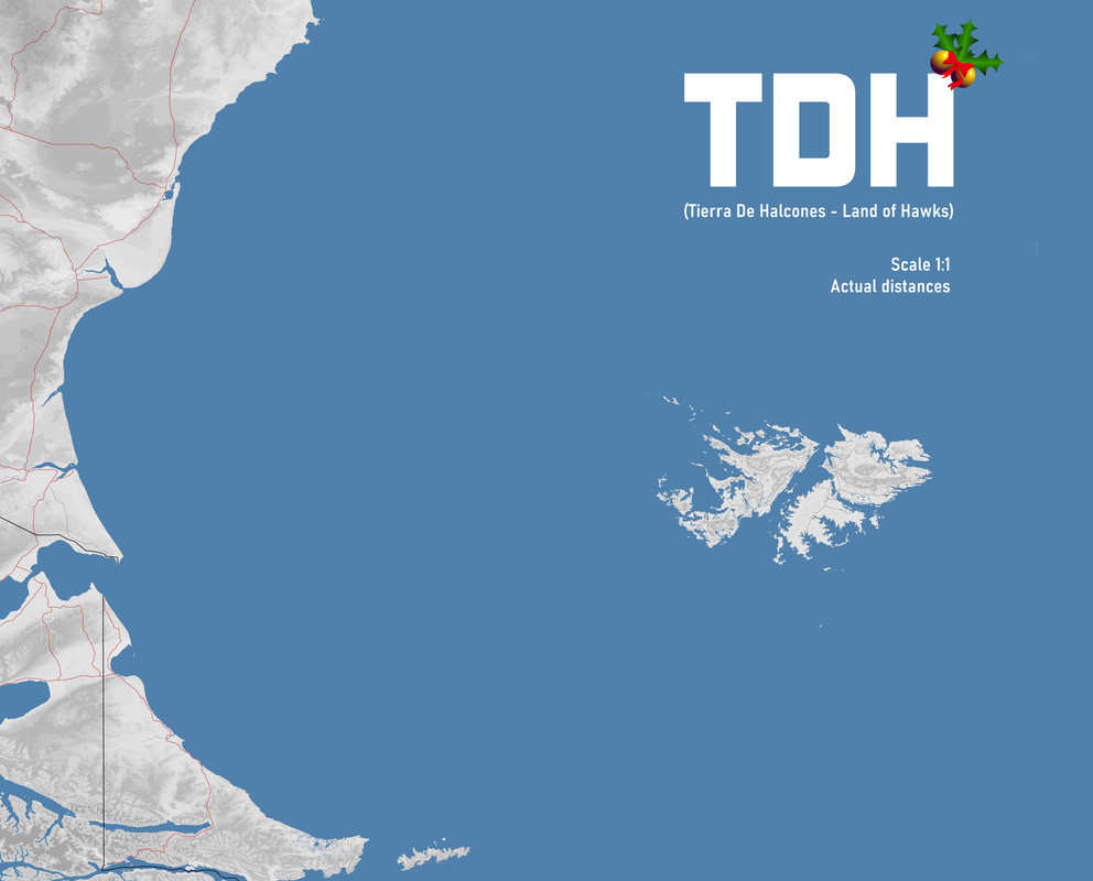
TDH, a 1:1 scale map of part of Argentine Patagonia, the Argentine Sea and the Malvinas-Falkland Islands. A new and extensive territory for offline and online missions and campaigns, although it has been created with the emphasis on online flight by human pilots.

1000 kilometers from west to east
806.4 kilometers from south to north

The TDH map is set in the period of the South Atlantic War, and although it is built from the Argentine perspective, with the names of the cities and towns as we know them in Argentina, this map is for everyone to enjoy, regardless of flags. We now have new territories to do missions and campaigns, or simply to wander around.

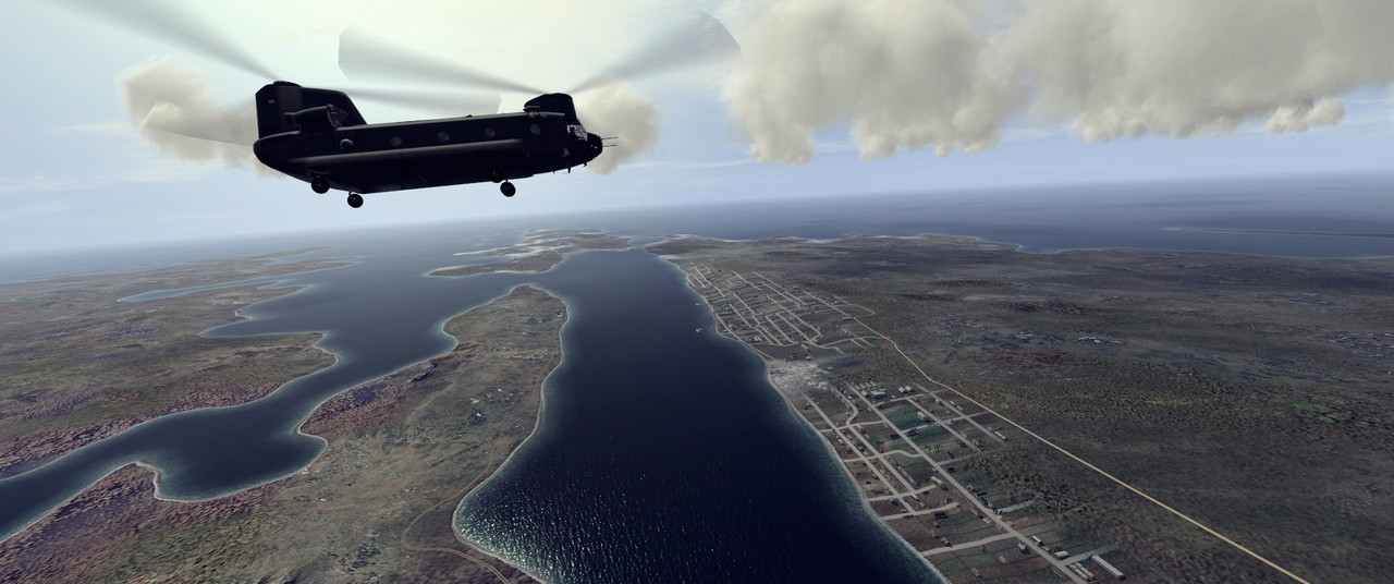
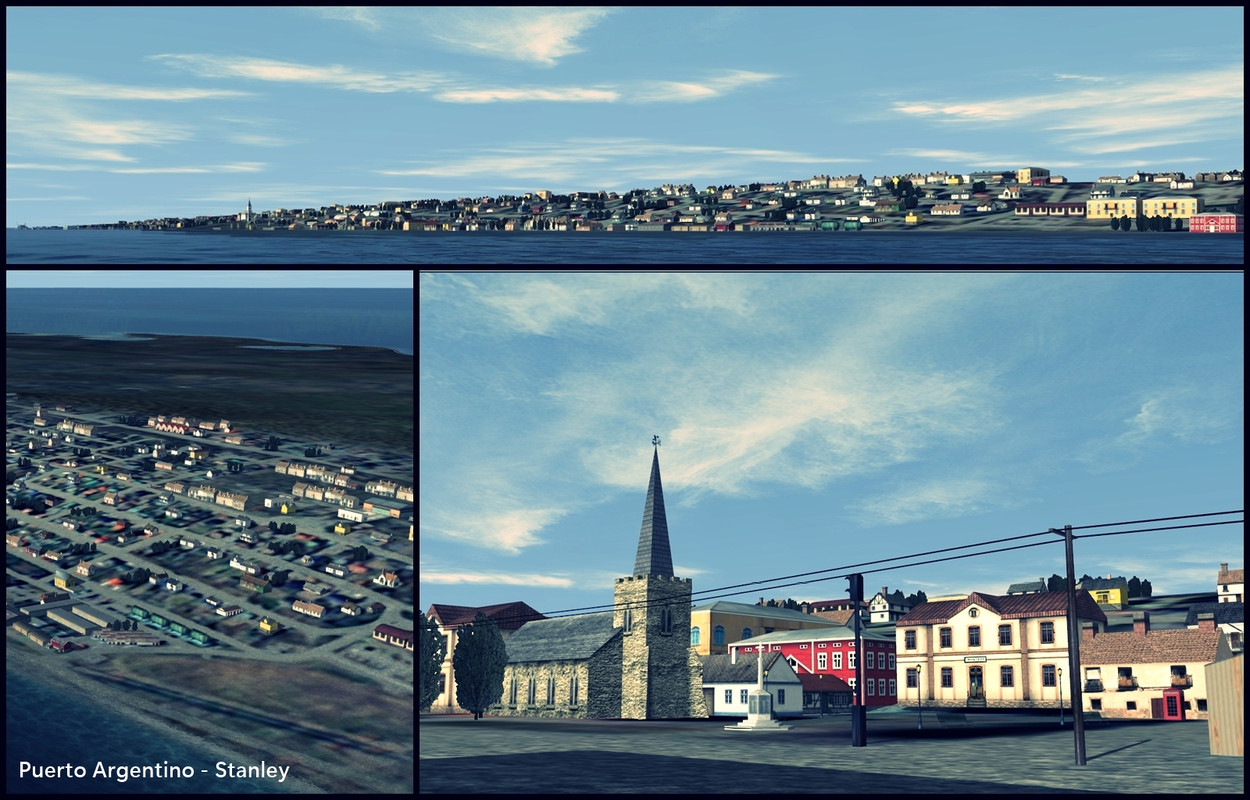
I have made every effort to represent in maximum detail all the small farms that exist on the islands, with the objects available in the game, and as far as I have been able to verify, these farms (or estancias, as we call them in Argentina) have changed very little from 1982 to the present day.

Many of these farms have small airfields, which are represented on the map in the same place as in reality, and have the same orientation and dimensions as the real runways, and their signage is similar, but they are hidden airfields (this is something I learned from master Seppel), you won't see these airfields on the navigation map unless you put a base on them. Then you won't have to worry about spawn points, they are already there, four per airfield. But I'm not going to tell you where these airfields are, you'll have to find them. The same goes for all the small ports on the islands, wherever there is a small dock, you can put a seaplane port, and you and three friends can leave from there. In the big bases or airports this rule of four spawn points does not apply, there are many more aircraft spawn points there.

As I just mentioned, the dimensions of the small farm runways are real, so it will be common to find runways of 250 meters or 300 meters in length. The decision to do this is to seek fidelity in the representation, and so that human pilots are the ones who face the challenge of landing and taking off on difficult runways. It is not a map designed for AI.

The main channels and bays of the islands are navigable, even the inner bay of Puerto Argentino or Port Stanley is navigable, and two ships have just enough space to cross at the entrance of the bay. The same happens in the bays of Fitz Roy and San Carlos, where large ships can navigate to the bottom of both bays. The heights of all the elevations on the map correspond to reality. Patagonia is an immense stone desert for training flights, for playing cold or hot war, or simply for getting lost.


The textures are my own and I made them following a method taught by Carsmaster. They are far from perfect, but for me, after many tests and over 100 discarded textures, they work pretty well. The map requires Carsmaster's dll 4096-2017.

This map is built on a BAT 3.6 version with TOAS mod, for that reason it also includes the TOAS mod objects. These objects are included with the download, as well as the installation instructions. I have tested the map simultaneously in BAT-TOAS 3.6, BAT-TOAS 4.1.3 (the TOAS version available on the SAS forum), and then, adding the necessary objects, I have tested the map in BAT-JTW 4.2.2.4, in BAT-JTW 4.2.3, and now also in BAT-JTW 4.3, always working perfectly and without problems.

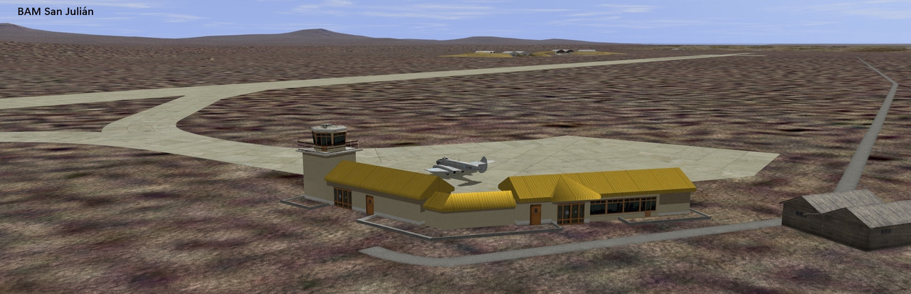
TDH also includes modifications made by GA9_Glaciar and FAL_Charly in the main air bases in Patagonia as well as in the BAM Calderón, BAM Cóndor and BAM Malvinas bases, work they carried out several years ago on the Baco South Atlantic map. On these modifications adjustments and corrections were made for its complete adaptation to TDH.


You should know that TDH was created to be flown with the highest graphic quality, in Perfect mode. If you lower the quality to Excellent or lower than that, you won't see it properly, you'll see oddities, you won't see the map as it was designed.

This is a very large map, and while I've kept it light to get the best performance possible (this is why Patagonian cities have very few houses), I can't guarantee that this map will open or run properly on a laptop with integrated graphics (we've already tested this and haven't been able to get it to perfect), or with 8GB of RAM or less (we haven't tested this). We've done the online tests with four similar computers, three of them with 16GB of RAM, and the fourth with 32GB of RAM. In my case I'm running a Ryzen 5 3600 with 16GB and a GTX 1060 6GB graphics card, and the map runs silky smooth, even in missions with a lot of activity.

So, to sum up the idea, if you have 8GB of RAM I can't guarantee that the map will work well, it's possible that it will, but since you have nothing to lose by trying, I encourage you to try it.

Finally, I recommend that if you are on BAT 4.3, do not add any effect mods, it works perfectly fine like this.


The map is presented in two versions, both set in the war between England and Argentina in the months of April, May and June of 1982.

Versión 1: TDH_Abril-1982
Versión 2: TDH_Junio-1982

The main difference between the two maps is the existence in the TDH_Junio-1982 version of the British base San Carlos FOB (Forward Operating Base), near the port of San Carlos, while in the TDH_Abril-1982 version such an advanced operating base had not yet been established, so in that place you will only find a small runway for the operation of small single-engine aircraft. In this case, this airfield is also for civil use, and therefore you will not see it on the navigation map, as happens with the rest of the civil airfields.

Credits:
This map would not have reached this level of development without the valuable assistance and collaboration of several friends who helped the project in different ways.

FAL_Charly, E69_Lezos and FAL_Imiguez, online test pilots, who together with this subscriber worked as a team for several weeks to test all the bases of the map.

FAL_Charly has even been collaborating with information and photographs from the very beginning of the project, material that allowed the recreation of many places in the Malvinas-Falkland Islands, for which he deserves special recognition here.

Huge thanks to them!

Download link for the TDH map with instructions inside:
https://www.mediafire.com/file/5zdee48mdxn86sn/TDH_2024.7z/file


*********************************************
GEORGIAS MAP


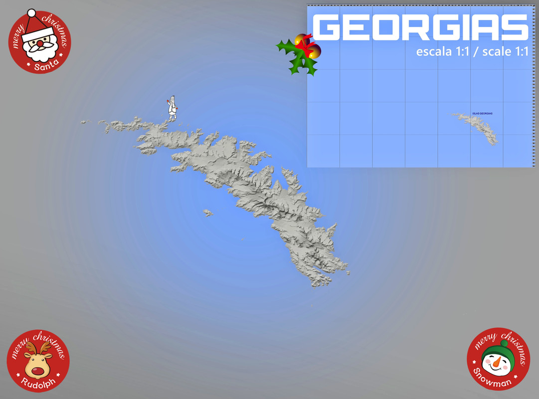
Since it's Christmas time, here's another map of the South Atlantic region, it's Georgia Islands. This map uses the same objects as TDH, so if you want to install it in your BAT game (from BAT 3.6 onwards) you can do so together with TDH.

This is a 1:1 scale map of Georgia Islands, it's actually a big island and several islets scattered near its coasts. The heights of the mountains are real and the whole orography of the place corresponds to reality. I have represented as faithfully as possible all the small towns and ports on the island. There are no land airfields here, it's a wild mountainous island covered with snow and glaciers running into the sea. However, in every port where there is a small dock, there you can put a seaplane port, and then four human pilots can leave from there.

The textures are my own. The map uses dll 4096-2017 from Carsmaster. This map has been successfully tested online. Enjoy it. Merry Christmas!

Download link for the GEORGIAS map with instructions inside:
https://www.mediafire.com/file/tu5di4ckax52qse/GEORGIAS_2024.7z/file
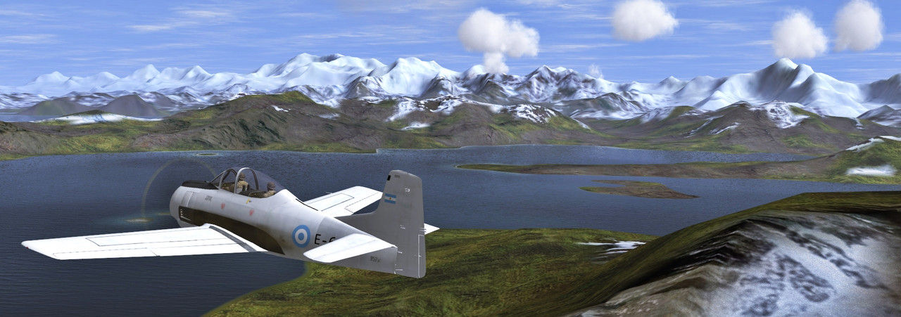


Logged

genXgamer

  • Modder
  • member
  • Offline Offline
  • Posts: 1453
Re: Two new maps of the South Atlantic seas
« Reply #1 on: December 21, 2024, 02:52:11 PM »

Excellent, thankyou!

Time to do some sightseeing.
Logged
Go in quickly - Punch hard - Get out!

UberDemon

  • UberDemon/danzigzag
  • Modder
  • member
  • Offline Offline
  • Posts: 1638
Re: Two new maps of the South Atlantic seas
« Reply #2 on: December 21, 2024, 03:35:45 PM »

WOAH!

I know I am Brazilian and all but Argentina is beautiful (as long as we don't talk about football or steaks...  :D).

If you are ever interested in doing a map of the Amazon Jungle that would be incredible.  Something along the Tri-Border area of Brazil/Venezuela/Colombia would be interesting.  Plenty of material for a Counter Narcotic campaign in the area using drug trafficking planes and Brazilian Tucanos and Super Tucanos which have shot down (and still do) narco-traffic planes.  If I recall, the Colombians have used the Super Tweet and AC-47s for counter-narco, counter-FARC operations.  Helos could also be used.

There is a great Natal/Northeast Brazil map in BAT.  I think the southeast and southern coast would be great for WW2 anti-submarine warfare.

Anyhoo, cheers.  Great maps.
Logged
Best Regards, UberDemon/danzigzag, Get UQMG at SAS BAT Mission area.  www.uberdemon.net no longer exists.  (** Alienware Aurora R7 / i7-8700 3.20GHz / 16GB RAM / Win 10 x64 / NVIDIA GeForce GTX 1080 **)

dogo77

  • member
  • Offline Offline
  • Posts: 2
Re: Two new maps of the South Atlantic seas
« Reply #3 on: December 21, 2024, 03:55:59 PM »

Que bien amigo felicitaciones, que gran trabajo.
Logged

UberDemon

  • UberDemon/danzigzag
  • Modder
  • member
  • Offline Offline
  • Posts: 1638
Re: Two new maps of the South Atlantic seas
« Reply #4 on: December 21, 2024, 03:59:46 PM »

Another scenario with a south-eastern/southern coast of Brazil would be something that happened during the Malvinas/Falkland Wars...

So... The Brits decided to fly an Avro Vulcan in Brazilian Air Space during the War.  Which of course was not cool.  Not sure if it was a mistake or just superiority complex.  The Brazilian Air Force (FAB) was always an extremely professional and well-trained military Air Force, having had great relations with the USAF since WW2, and benefitting from technology exchanges and training with USAF and other NATO partners.  Brazil made one of the largest purchases of F-5s (around 85 or so)... and like many countries after observing the Israeli use of Mirage III aircraft to great effect, also acquired Mirage IIIs, which were considered the primary fighter-interceptors, while the F-5s were fighter-bombers.

Mirage IIIs were scrambled to intercept the Vulcan which I am sure was not pleased to see very modern, very disciplined fighter and fighter pilots who spoke in English to them and told them basically, follow them.  The else is implied.  The Vulcan landed in a Brazilian Airport, and it was impounded for the remaining of the war.  It was returned to Her Majesty after the war (Big fan of Queen Elizabeth, and may her soul rest in peace).

As dramatic and exciting as that was for the Brazilian population, the story of the RAF crew is much different.

They stayed with their plane during the impound.  Under terrible conditions.  The were forced to get sun-screen and tanning chairs... they were forced to relax in the great Brazilian outdoors while Brazilian girls across the fence would go crazy for those "blonde" men with "blue eyes" and would bring them Brazilian home-cooked food and treats.

Yeah... tough conditions.

In this era of Google, I should know better and do research, but this is what I remember when I was a kid, and that is what I saw on TV and read on the newspapers of the time.

Anyhow, sorry for placing my wishes here, and I do not want to detract from the fact that these Argentina maps are gorgeous.  Well done.  Please make more like them.  I'll surely use them, and I hope to see them in the next BAT update.  Until them, I'll have them as mod additions.  May I make a suggestion?  It would be nice to have a few sample missions with the map release.
Logged
Best Regards, UberDemon/danzigzag, Get UQMG at SAS BAT Mission area.  www.uberdemon.net no longer exists.  (** Alienware Aurora R7 / i7-8700 3.20GHz / 16GB RAM / Win 10 x64 / NVIDIA GeForce GTX 1080 **)

vonofterdingen

  • Missioneer
  • member
  • Offline Offline
  • Posts: 1366
Re: Two new maps of the South Atlantic seas
« Reply #5 on: December 21, 2024, 04:00:28 PM »

Very nice work, Haukka. Thanks a million.
Logged

E69_Haukka

  • Mapper
  • member
  • Offline Offline
  • Posts: 80
Re: Two new maps of the South Atlantic seas
« Reply #6 on: December 21, 2024, 07:08:43 PM »

Thank you for your good concepts, GenXgamen, UberDemon, Dogo77 and Vonofterdingen. Welcome to the South Seas!

UberDemon, I loved your proposal for a map of the Amazon rainforest for anti-narcotics campaigns, you and I will talk more about this. All ideas are welcome, there is no need to apologize for expressing your wishes. Have a good flight, friends!

PS: I will upload some test missions soon.
Logged

CDS025_DOGO

  • member
  • Offline Offline
  • Posts: 211
  • Saludos Camaradas
Re: Two new maps of the South Atlantic seas
« Reply #7 on: December 22, 2024, 09:09:07 PM »

Vaya que sorpresa tan bonita Haukka un enorme gracias, merecidas felicitaciones por tamaño trabajo, ,me alegro por todo el equipo charly, Lezos ( tengo el gusto de conocer) y demás integrantes. Se podría decir que es un regalo de navidad, jajajaja gracias chicos.

Wow, what a nice surprise Haukka, a huge thank you, well-deserved congratulations for such a great job, I'm happy for the whole team Charly, Lezos (I have the pleasure of knowing) and other members. You could say it's a Christmas present, ajajajajaja, thanks guys.

excuse the grammar translated with google translator
Logged

E69_Haukka

  • Mapper
  • member
  • Offline Offline
  • Posts: 80
Re: Two new maps of the South Atlantic seas
« Reply #8 on: December 23, 2024, 10:46:35 AM »

Vaya que sorpresa tan bonita Haukka un enorme gracias, merecidas felicitaciones por tamaño trabajo, ,me alegro por todo el equipo charly, Lezos ( tengo el gusto de conocer) y demás integrantes. Se podría decir que es un regalo de navidad, jajajaja gracias chicos.

Wow, what a nice surprise Haukka, a huge thank you, well-deserved congratulations for such a great job, I'm happy for the whole team Charly, Lezos (I have the pleasure of knowing) and other members. You could say it's a Christmas present, ajajajajaja, thanks guys.

excuse the grammar translated with google translator

I'm glad you like it, CDS025_DOGO! Now to do missions, campaigns, and fly. Greetings!
Logged

Yaro59

  • member
  • Offline Offline
  • Posts: 947
Re: Two new maps of the South Atlantic seas
« Reply #9 on: December 23, 2024, 11:05:30 PM »

Another scenario with a south-eastern/southern coast of Brazil would be something that happened during the Malvinas/Falkland Wars...

So... The Brits decided to fly an Avro Vulcan in Brazilian Air Space during the War.  Which of course was not cool.  Not sure if it was a mistake or just superiority complex.  The Brazilian Air Force (FAB) was always an extremely professional and well-trained military Air Force, having had great relations with the USAF since WW2, and benefitting from technology exchanges and training with USAF and other NATO partners.  Brazil made one of the largest purchases of F-5s (around 85 or so)... and like many countries after observing the Israeli use of Mirage III aircraft to great effect, also acquired Mirage IIIs, which were considered the primary fighter-interceptors, while the F-5s were fighter-bombers.

Mirage IIIs were scrambled to intercept the Vulcan which I am sure was not pleased to see very modern, very disciplined fighter and fighter pilots who spoke in English to them and told them basically, follow them.  The else is implied.  The Vulcan landed in a Brazilian Airport, and it was impounded for the remaining of the war.  It was returned to Her Majesty after the war (Big fan of Queen Elizabeth, and may her soul rest in peace).

As dramatic and exciting as that was for the Brazilian population, the story of the RAF crew is much different.

They stayed with their plane during the impound.  Under terrible conditions.  The were forced to get sun-screen and tanning chairs... they were forced to relax in the great Brazilian outdoors while Brazilian girls across the fence would go crazy for those "blonde" men with "blue eyes" and would bring them Brazilian home-cooked food and treats.

Yeah... tough conditions.

In this era of Google, I should know better and do research, but this is what I remember when I was a kid, and that is what I saw on TV and read on the newspapers of the time.

Anyhow, sorry for placing my wishes here, and I do not want to detract from the fact that these Argentina maps are gorgeous.  Well done.  Please make more like them.  I'll surely use them, and I hope to see them in the next BAT update.  Until them, I'll have them as mod additions.  May I make a suggestion?  It would be nice to have a few sample missions with the map release.
Very interesting story. Thank you for sharing it.
Logged

UberDemon

  • UberDemon/danzigzag
  • Modder
  • member
  • Offline Offline
  • Posts: 1638
Re: Two new maps of the South Atlantic seas
« Reply #10 on: December 24, 2024, 07:58:37 PM »

Very interesting story. Thank you for sharing it.

Thank you Yaro.  I went back to look more into the incident and realized I was wrong...  the interceptors were indeed F-5s, and not the Mirages.  The additional information about "Operation Black Buck", #6 for the mission I mentioned is very interesting:  https://en.wikipedia.org/wiki/Operation_Black_Buck

Quote
Black Buck Six was flown on 3 June by McDougall, whose Vulcan was now armed with four Shrike missiles instead of just two. Montgomery again flew the reserve aircraft. McDougall loitered over the target for 40 minutes in a vain effort to engage the AN/TPS-43, which was not switched on. Finally, the crew fired two of the four Shrikes, which destroyed a Skyguard fire-control radar of the Argentine Army's 601 Anti-Aircraft Battalion, killing four radar operators.[28]

On its return flight McDougall was forced to divert to Rio de Janeiro after his in-flight refuelling probe broke. One of the missiles he was carrying was ditched into the ocean to reduce drag, but the other remained stuck on the pylon and could not be released. Sensitive documents containing classified information were jettisoned into the sea via the crew hatch, and a "Mayday" signal was sent.[28][65] Two Northrop F-5E Tiger II fighters from 2° Esquadrão do 1° Grupo de Aviação de Caça of the Brazilian Air Force were scrambled from Santa Cruz Airfield and intercepted the Vulcan.[66] The aircraft was cleared to land at Galeão Airport by Brazilian authorities with less than 2,000 pounds (910 kg) of fuel remaining, not enough to complete a circuit of the airport.[28]

This was a potentially embarrassing international incident, as it revealed that the United States had supplied the British with Shrike missiles. British diplomats negotiated for the release of the Vulcan and its crew, who were interned at Galeão Air Force Base. A deal was struck on 4 June under which they would be released in exchange for spare parts for Westland Lynx helicopters.[67] Brazil came under pressure from Argentina, and the United States agreed to intervene to preserve the secrets of the Shrike missile. The crew and aircraft were permitted to fly to Ascension on 10 June. A new refuelling probe was fitted there, and the aircraft flew back to Waddington on 13 June.[28] The remaining Shrike missile remained in Brazil.[66][68]

I can tell you though, it is funny to read all about it now... it was reported much differently back in the 80's.
Logged
Best Regards, UberDemon/danzigzag, Get UQMG at SAS BAT Mission area.  www.uberdemon.net no longer exists.  (** Alienware Aurora R7 / i7-8700 3.20GHz / 16GB RAM / Win 10 x64 / NVIDIA GeForce GTX 1080 **)

Glaciar

  • member
  • Offline Offline
  • Posts: 95
Re: Two new maps of the South Atlantic seas
« Reply #11 on: December 26, 2024, 06:25:36 AM »

Que bueno es ver este mapa tan temprano!! Felicitaciones al equipo liderado por Haukka y secundado por Charly y demás amigos que me alegra que formaran parte!

Entiendo que le daría mucho mas realismo a las misiones en cuanto a tiempos, consumo y lo mas importante, la navegación! ya que durante la guerra, los pilotos sufrían estas tres cuestiones antes de llegar a las islas siquiera. Por no contar con un adecuado equipo de navegación ni las radio ayudas necesarias, volaban mirando el mapa, mirando el suelo. Y esto, sin duda se va a trasladar a la simulación si se llega hacer una misión.

Así que los felicito! por tan ardua labor!

Por otra parte, habiendo sido quien "acomodó" un poco las bases de la Patagonia, por el hecho de haberlas caminado simplemente, me parece importante resaltar para futuros updates para darle mas realismo un par de cuestiones.

1. El aeropuerto de Ushuaia, donde vivo ahora, recién se crea en 1995.
2. En Río Gallegos, habían coexistido tres pistas de aterrizaje durante la guerra. La primera y mas importante es el actual Aeropuerto y asiento de la X brigada aérea desde donde la Fuerza Aérea operó como se conoce. Luego estaba la Estación Aeronaval, en la zona de la desembocadura del Rio Chico al estuario, que actualmente hay rastros de la pista, queda el hangar, pero esos terrenos se han cedido a la Universidad Nacional de la Patagonia Austral. Y por ultimo lo que actualmente es el Aeroclub, que en esa época tenia tres pistas de tierra y el Hangar creado para dar servicio a Aeropostale, cuya ubicación es mas hacia el oeste de la pista que está creada en su nombre.
3. Al mismo tiempo, las ciudades patagónicas no eran tan grandes en ese entonces, me pasó por ver Rio Gallegos que se ven las texturas de ciudades al lado de la base y en realidad esas construcciones son del 2019 en adelante.
4. Las texturas de la Patagonia lo hacen ver como un desierto gigante. Pero calculo que es la idea generalizada que se tiene en el norte de como es en realidad. Ya que, si bien no existen grande extensiones de bosques, la zona patagónica "desértica" presenta un tipo de mata verde que cubre la mayor parte del terreno y le da muchos matices. Cada cierta distancia, mas en la zona de Santa Cruz, existen muchos ojos de agua que le dan un toque verde al paisaje no haciéndolo tan monótono. Además, de que existen accidentes geográficos muy marcados como salares, ríos, bañados, vegas, cañadones, causes de ríos, yacimientos petroleros, antiguas estancias y paradores, puentes, puertos, buques encallados y restos de naufragios, etc..

En fin, me alegra ver que el mapa haya salido a la luz. Solamente puntualicé en esos detalles para que sea constructiva, los pueden tomar o no..

Gracias por el tiempo que le han dedicado!
 
Logged
Pages: [1] 2   Go Up
 

Page created in 0.028 seconds with 20 queries.