Special Aircraft Service

Please login or register.

Login with username, password and session length
Advanced search  
Pages: 1 ... 5 6 7 [8] 9 10   Go Down

Author Topic: North Sea 0.5beta  (Read 52666 times)

0 Members and 3 Guests are viewing this topic.

Wa99el

  • member
  • Offline Offline
  • Posts: 50
Re: North Sea 0.5beta
« Reply #84 on: October 24, 2019, 02:24:18 PM »

The map_c of England is making progress. Meanwhile, I have continued to work until Liverpool. For a change, I worked again at an airfield. Today, I want to show how I use the help of old aerial photography to create a texture. The texture later becomes important when I insert the airfield into the map of Sturmovik FMB+.

First I choose from Google Maps the area of the old airfield in a certain scale:


I copy the necessary details of the terrain into my Photoshop and place them in a so called Layer. I compare the
current picture with the old aerial photograph and mark structures that match red, such as streets, forests, buildings, etc.


Now I add the old aerial photograph from World War II on the current inclusion in its own layer.

I need to scale the shot, rotate it, and I use the command Edit -> Puppet Warp from the Photoshop tools in order
to place the old aerial photo 100% perfect.

The old aerial photographs are never 100% made from a 90 degree angle. This creates spatial distortions.
With Puppet Warp I know about removing these distortions by 99%.

This takes a while ]coffee[


If the old recording is placed correctly, I start working out the old streets, paths, runways. I'm looking for
buildings on the airfield. Since I have now put the old recording on the current recording with the correct
scale, I can calculate lengths and dimensions. The old runways had a width of 80 meters (quite wide) and
they were 1200 meters long. This coincides with the statements of historians who have inspected this old airfield.

At the buildings I proceed likewise. Although I can not see how tall the buildings are, I can gauge the height
of other shadows. In addition, the statements of the historians help me.
Logged

Wa99el

  • member
  • Offline Offline
  • Posts: 50
Re: North Sea 0.5beta
« Reply #85 on: November 10, 2019, 04:00:39 PM »


At the moment I am working on several construction sites. In addition to my move to the new house,
I continue to work on the North Sea map.

+++++++++++++++++++++++++++++

Source Pages

I started a lot of research on the internet. I found the following pages:

http://topotijdreis.nl/ Historical maps of the neatherlands
https://ncap.org.uk/ UK site with aerial photos from WW2
https://archive.org/details/AFD-100525-035 Combat Chronology of the Army Air Forces in WW2
http://www.8thafhs.org/ 8th Air Force Historical Society
SAS Page with german radar objects made by CanonUK (WIP)

Unfortunately, I have not found much information about the French airports. Maybe someone of you
has some sources.

+++++++++++++++++++++++++++++

I am making good progress in the field of map_c. Many coastal regions of Great Britain, Netherlands and
Germany are ready. Today I went on with the region of Scapa Flow.

On 14 October 1939, under the command of Günther Prien, U-47 penetrated Scapa Flow and sank the
First World War-era battleship HMS Royal Oak anchored in Scapa Bay.

More intresting for us: Three days after the submarine attack, four Luftwaffe Junkers Ju 88 bombers of I/KG30
(Jever - Ostfriesland/Germany) led by group commander Hauptmann Fritz Doench raided Scapa Flow on 17 October in one of the first
bombing attacks on Britain during the war. The attack badly damaged an old base ship, the decommissioned
battleship HMS Iron Duke, which was then beached at Ore Bay by a tug.

The map will include Bergen and Olso. So there is the possibility to to make somescenarios with the occupation of Norway shortly before
the "Westfeldzug". Many british and german air operations.

In addition, I have the coast of western France in work. I still have to complete the satellite data from Central France with Microdem.


For the first time it will be possible to create the complete operation Cerberus in IL-2 as a scenario.
If everything works, there may be some modders building the ships Gneisenau, Scharnhorst and Prinz Eugen.


I am also working on a word document with a lot of informations about airfields and stationed are units.
I am also writing down the main battles in the west with some usefull informations to make historical
scenarions on the map. In the near future I will make a first upload oh this document. I also will name
the sources so that everybody can read the books with much more informations.
Logged

Mission_bug

  • Modder
  • member
  • Offline Offline
  • Posts: 6083
Re: North Sea 0.5beta
« Reply #86 on: November 12, 2019, 10:21:43 AM »

Looks like things are coming along very well Wa99el. 8)

Certainly looking forward to the finished map although it looks like you have a lot of work to do.


Wishing you  all the very best, Pete. ;D
Logged

Wa99el

  • member
  • Offline Offline
  • Posts: 50
Re: North Sea 0.5beta
« Reply #87 on: November 12, 2019, 01:48:01 PM »

It looks good. Right now I'm getting more sources than I can handle them. :o I will first
sort out the sources to analyze later and finally I will incorporate the information into
the creation of airfields, regional structures and historical events that will be summarized
in the word document for historical missions and scenarios.

The processing of the satellite data and the transformation into a graphic
was a challenge (Microdem). I had problems connecting larger amounts of single satellite data.
Maybe it's up to my computer, but I did not have full memory and CPU utilization.  :-X

I have decided to use for the map_c a graphic with the ratio 1 pixel = 200 meters. That's enough.
With the graphics editor I will inflate/blow up the graphics to 1 pixel = 50 meters. It was important to
create the satellites graphics in one part (consisting of 18 individual data). This is probably
because of the curvature of the earth, certain sheet dimensions must be adhered to, so that
the individual graphics fit together.  o_O Sometimes you do not know what you are doing exactly, but it fits :-)

Finally here is something for you:

11.11.2019


Logged

mandrill

  • Modder
  • member
  • Offline Offline
  • Posts: 785
Re: North Sea 0.5beta
« Reply #88 on: November 12, 2019, 05:08:59 PM »

Waggel, how much are you going to populate?

I have a Germany map that I remade from Spit's (?) map of a couple of years ago. But I was afraid that full population would make it unloadable and I never finished it for that reason.

Your new North Sea map is far bigger!
Logged

Wa99el

  • member
  • Offline Offline
  • Posts: 50
Re: North Sea 0.5beta
« Reply #89 on: November 14, 2019, 12:19:33 PM »

It's going to be that I want to cover as much as possible with objects. I will use the auto pop program. This will allow me to fill the towns and cities very quickly and efficiently with objects.

With a special composition of objects, the cities will not be a problem for the performance of the hardware.

For example, in cities I will work a lot with whole streets- and block objects. So you have one object and 4 to 5 houses.

That worked well with my old map. Cities like Hamburg or Bremen were good to fly over. Even with my old computer.

Much work will be done on the Map_C and creating the airfields. Very individual work.
Logged

mandrill

  • Modder
  • member
  • Offline Offline
  • Posts: 785
Re: North Sea 0.5beta
« Reply #90 on: November 14, 2019, 04:28:57 PM »

Ok. When the time comes, allow me to offer buildings that I made myself. Essentially British style row housing. 4-house and 2-house blocks. And I wold be happy to make others.

Factory and office building blocks. Strip malls.
Logged

Wa99el

  • member
  • Offline Offline
  • Posts: 50
Re: North Sea 0.5beta
« Reply #91 on: November 26, 2019, 01:36:48 PM »

Thanks for the support Mandrill. Personally, I am very good at graphics. The development of 3D objects was explained to me recently. I have not yet worked into the 3D workspace. If you like the work on 3D objects, there are certainly some possibilities for the map. My first thought was towards train stations, churches, distinctive buildings in general. Something like that brings life to the map.

Here is an overview of the North Sea Map, as I imagine.


My plan was to go further north with the map and less to the south (Alps). Unfortunately, there is no satellite data north of Olso.
The map contains regions for many historical scenarios.

Logged

Wa99el

  • member
  • Offline Offline
  • Posts: 50
Re: North Sea 0.5beta
« Reply #92 on: November 28, 2019, 03:57:05 PM »

Today I saw this here:

https://www.sas1946.com/main/index.php/topic,60996.msg691595.html#new

The heavy cruiser Hipper is on its way into IL-2 1946. I asked ashhouse if he can make a second Prince Eugen slot and copy the hipper stuff into it.
Logged

Mission_bug

  • Modder
  • member
  • Offline Offline
  • Posts: 6083
Re: North Sea 0.5beta
« Reply #93 on: November 30, 2019, 04:57:41 AM »

That really is a very large area, a formidable task ahead I think, certainly covers most of what we might want as players for Europe. 8)

As for objects, Cannon made many that are particularly useful for the U.K., others have done the same for France so you should have a good start there once you start to populate. ;)

Any 3d modeller could spend a lifetime trying to make some of the more unique objects required for what is a immense area, however, might be worth putting up a request thread for anything you feel is particularly important to the project and if it can be made then I am sure some will have a go at some things for you, others you might have to make do with what is available.

If possible it would help to post scale drawings if possible, it is difficult to work from some images without some detailed measurements.


Wishing you all the very best, Pete. ;D
Logged

Wa99el

  • member
  • Offline Offline
  • Posts: 50
Re: North Sea 0.5beta
« Reply #94 on: November 30, 2019, 11:16:06 AM »

CanonUK has done a lot with his mapwork. His objects (houses, etc.) are ideal for the North Sea Map.

Sadly he has not been seen in this forum in recent years. I hope he is fine.


3D work made by Joe (CanonUK)

Today I found a page here in the forum with work by CanonUK in the field of German radar.

Link

From what I know from the past we already have radar and radiobeacon in game (very nice).

Right now I'm researching British radar stations. I also found a lot of airfields with information
in the area of the map. For the visual overview, I carry the found locations into a prepared
map
, which I have put together from the satelite data. So I save myself the work, because
later I can simply transfer the locations into the "ed_m.tga".

I fully agree with you. Despite all the organization, I will not be able to manage this
project on my own. That's why I'm looking here in the forum for projects that are
related to the North Sea map. Example asheshouse: He is currently working on the ship
model of the Hipper. The heavy cruiser Hipper (Infos on Wikipedia) fits very well into the North Sea project,
as many of its home ports and application areas are on the map.


3D model of the heavy cruiser "Admiral Hipper". Picture made by Asheshouse (Source)

Asheshouse is buisy with the Hipper but maybe he later will work on the Prince Eugen and maybe Blücher (sister ships that are very similar)

Mandrill wants to make 3D objects for Britain.

I will continue to look for projects in this forum and I will be thinking about which objects in the form of airplanes, ships and buildings would make sense for the North Sea Map.

Logged

Wa99el

  • member
  • Offline Offline
  • Posts: 50
Re: North Sea 0.5beta
« Reply #95 on: December 01, 2019, 10:18:33 AM »


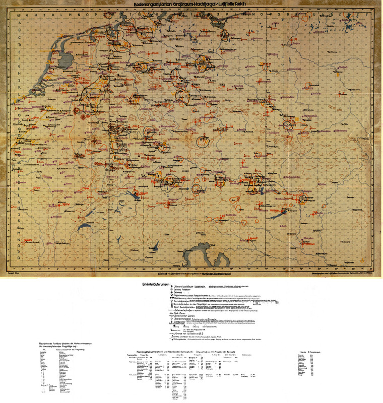
Yesterday I received a scan from an original map of the German Air Force.
On the map are large parts of the North Sea Map mapped. Various ground
organizations of the German Air Force are shown. Very interesting are the
so-called "Funkmeß positions" in the map, which show the radar stations
of the German Air Force. Also interesting are the camouflage names for
these structures. An essential part of these positions was equipped with
the so-called "Würzburg Riesen".

++++++++++++++
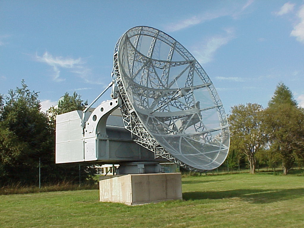


Würzburg Riese (Translation: Würzburg Giant)

The "Würzburg Riese" is a radar device from Telefunken and served during the air war in
the Second World War to locate enemy aircraft. It was an enlarged version of the FuMG 62
Würzburg and used like this frequencies around 560 MHz ("Dezimeterwellen"). Technically
demanding was the precise control of the 11-ton rotating part of parabolic mirror and control
cabin, which was realized with a Leonardsatz developed by the AEG.

Introduced in mid-1941, the fixed "Riesen" (camouflage: radio transceiver FuSE 65 or radio
measuring device - FuMG 65) were used to guide the Luftwaffe night fighters and were
installed on the towers of the large flak towers for fire control. The mobile "Würzburg Riesen"
FuSE 65 E were mounted on railway wagons, while the stationary version for the
Kriegsmarine was the "Funkmess-Ortungsgerät FuMO 214", which was used for the fire
control of their coastal artillery (eg the fortress Fjell).

Tecnical Data:


Mirror diameter: 7.5 m
Focal length: 153 cm
Wavelength: 53 cm
Frequency: 560 MHz
Bandwidth: 500 kHz
Pulse repetition frequency: 1875 Hz
Pulse width: 2 μs
Antenna gain: 32 dBi
DF accuracy: 0.25 degrees
Receiver sensitivity: 250 kT0
Range to destinations: 250 km *
Weight of the rotatable part: 11 tons

*Source: Directory of German Radar Equipment, War Department Tech. Manual TM E 11-219, Apr. 1945.

Edit: In the german Wikipedia it is written, that the Range to destinations was 60-80 km. But there is no Source.
I have not the knowledge of the technology of this plant, to say: one statement is correct or the other.
Maybe there are some experts here who know that exactly.

++++++++++++++

German Airfields

On the map some airfields of the German Air Force are drawn, which I did not know yet. So that's another step forward. Also interesting is an additional tabular inscription in which the length of the runways is drawn.

++++++++++++++

Additional Information

Other structures in the map deal with radio beacon. Larger air defense- and headlight areas are visible. Overall, this historic map will help significantly to improve the North Sea project.


Logged
Pages: 1 ... 5 6 7 [8] 9 10   Go Up
 

Page created in 0.037 seconds with 24 queries.