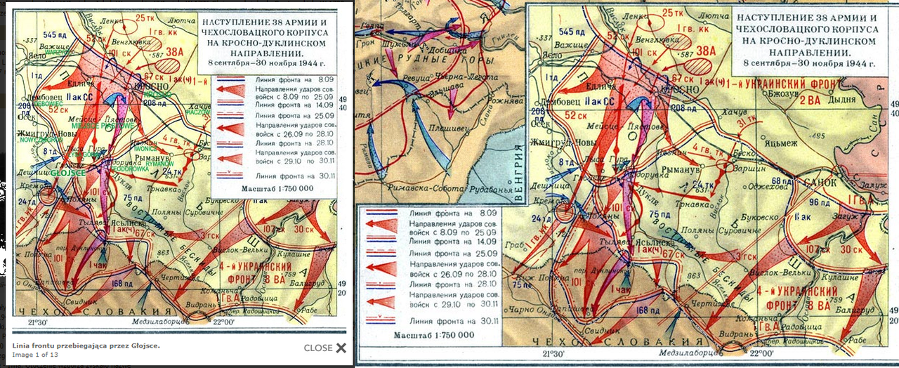
Map of Dukla-Prešov Operation (Battle for the Dukla Pass) http://www.iabsi.com/gen/public/Military_dukla_pass.htm
 (eng)
https://www.dukla1944.com/udalosti/boje-mistniho-vyznamu-a-zaujeti-obrany-na-ondave-29-10-30-11-1944/ (sk) or (cz)
https://en.wikipedia.org/wiki/Battle_of_the_Dukla_PassIn my opinion, the battle for the Dukla Pass was one of the biggest battles of WWII, unfortunately, rarely mentioned today,
although it was mainly a battle of armoured troops and infantry, in its initial phase and also during its duration a lot of air force was used.
There were not rather spectacular air battles here, but dogfights also took place over the Carpathian sky.
I think that if it had been created, it would have been a great map, meeting the needs of many Sturmovik users including me.
map of Dukla and surrounding areas (in Russian) 137mb!:
https://drive.google.com/file/d/1iZuybFVarIb2DtELnFiy7DA0JBr9hyi-/view?usp=sharingmap of the Polish-Slovak borderland (German map) 438mb!:
https://drive.google.com/file/d/1remnLSm3VEYZTyLaWwbAsUNc_YVvbJIu/view?usp=sharingThe Dukla-Presov Operation (also known as the Carpathian-Dukla Operation, the Battle of the Dukla Pass, the Dukla Offensive, etc.) is a major military operation of the Red Army in September and October 1944 near the Dukla Pass, from the vicinity of Dukla near Krosno in the north to Prešov in Slovakia in the south, from the vicinity of Polan in the west to the vicinity of the Lupkowska Pass in the east.

From the dawn of 8 September to 30 November , 1944, this area became a place of fighting and burial of about 99 thousand Red Army soldiers, mainly Ukrainians, Slovaks and German soldiers. Losses of Soviet troops amounted to about 123 000 killed, wounded and missing. The Czechoslovak troops lost about 6500 soldiers, while German and Hungarian losses are estimated at almost 70 000 people. The Dukla Operation was one of the bloodiest episodes of World War II on Polish soil, and one of the battlefields near Chyrowa, where a bloody armored battle took place, was called the "Valley of Death".
The German command attracted considerable forces and strengthened the area, creating the so-called "Karpatenfestung" (see the Arpad Line). German troops had 18 divisions, including 3 armoured ones (in total about 100 thousand soldiers), 350 tanks and 2000 cannons. Although the tanks of the Red Army reached Korczyna and the suburb of Krosno on 22 July 1944, the front stopped north of the city. The Germans had time until September to man the hills and hare favorable positions.


Translated with
www.DeepL.com/TranslatorMore comprehensive info:
The Battle of the Dukla Pass, also known as the Dukla / Carpatho-Dukla / Rzeszów-Dukla / Dukla-Prešov Offensive was the scene of bitterly contested battle for the Dukla Pass (borderland between Poland and Slovakia) on the Eastern Front of World War II between Nazi Germany and the Soviet Union in September–October 1944. It was part of the Soviet East Carpathian Strategic Offensive that also included the Carpathian-Uzhgorod Offensive. The operation's primary goal to provide support for the Slovaks was not achieved, though it concluded the full liberation of the Ukraine in its modern borders by the occupation of the Subcarpathian region as a territory of the former Carpatho-Ukraine.

The main goal of the Operation was to capture the town of Prešov at the territory of Slovakia within 5 days and this manner to help the fighters of Slovak National Uprising which began at the territory of Slovakia on 29 th August 1944 (more information in the section “Facts about Slovak National Uprising”).

After sharp bombardment the first wave of attack was focused to capture the town of Krosno but this goal was not achieved which caused a lot of following difficulties on the side of Allied units. Soviet and Czechoslovak forces advanced toward first German defense position established on the hills near of villages Wrocanka and Machnówka where took place the fist serious combat with German forces. Especially, the 3 rd Czechoslovak Infantry Brigade suffered serious casualties caused by counter-attacking German infantry and tank units.
Moreover, one of the biggest clashes of the Operation happened around and on Hill 534 in the northwest from the town of Dukla . This hill had big strategic value for both sides involved in the Operation. The battle to capture this hill lasted from 10 th September to 20 th September 1944 . During these days the hill changed its “owners” more than 20 times. On 20 th September 1944 Germans retreated to the town of Dukla . The next strategic point of German defense was Hill 694 “Hyrowa Hora”.
1 st Czechoslovak Infantry Brigade supported by 4 tanks of
1 st Czechoslovak Tank Brigade in order to capture this hill carried out marvelous attack on 22 nd September 1944 with a positive result. Germans were surprised attacking tanks because their usage was not expected in terms of a severe terrain. The town of Dukla was seized on 21 st September 1944 by 3 rd Czechoslovak Infantry Brigade supported by tanks of 4 th Soviet Guard Tank Corps and 140 th Soviet Infantry Division on the left flank.
After a short rest and reorganization of Allied troops the Operation continued by the attack straightforward to the former Czechoslovak State Border. The combat to seize the Dukla´s Pass directly at the former state border began on 27 th September 1944 . At the state border Germans built up the second defense position with many of trenches, wooden bunkers, minefields and obstacles against infantry, armored vehicles and tanks. The state border and Dukla´s Pass was captured on 6 th October 1944 .
From the state border German units retreated to the third defense position which was established 6 kilometers in the south behind the state border with the centre of defense on Hill 532 “Obšár”. This defense position was prepared the best way within the Operation with many of wooden bunkers and machine guns´ pillboxes and foxholes. German artillery batteries were very effective used because their spotters were dressed in civil clothes equipped the radio and they were infiltrated in local population living in the small villages near Dukla´s Pass. All roads and paths were heavily mined. During this Operation in the fist time of history WWII were massively used German anti-tanks weapons famous under the name “Panzerfaust” and “Panzerschreck”.
old photo (scroll down when you open the page):
http://www.draganowa.info/Galerie%20zdjec/galeria%202.htmhttp://glojsce.pl/historia.phpThe valley of death today:
http://glojsce.pl/galeria.phpThe battle to capture Hill 532 “Obšár” started as soon as Allied forces crossed the state border. The Operation finished on 28 th October 1944 bellow the summit of Hill 532 “Obšár” because of Slovak National Uprising failed. The hill was definitively secured as late as on 25 th November 1944 , too late.
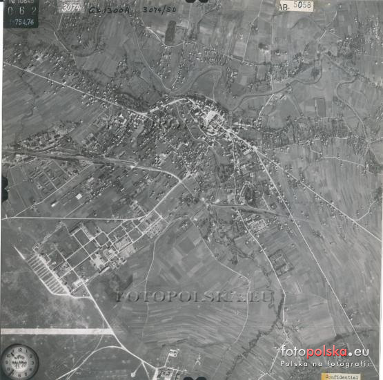
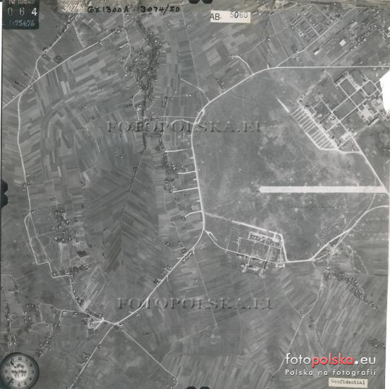
Information about the airport Krosno, Krosno-Iwonicz (a.k.a. Krosno-Łężany), Krosno-Moderowka :
Luftwaffe Airfields 1935 - 1945 by Henry L. deZeng IV.
http://www.ww2.dk/Airfields%20-%20Poland.pdfKrosno (POL) (a.k.a. Altkirch) (49 41 25 N – 21 44 30 E)
General: airfield in S Poland 170 km SE of Kraków and just W of Krosno. History:
built1937-38 as the new home for the Polish Air Force NCO training center for pilots, flight
engineers, gunners and radio operators. Surface and Dimensions: artificially drained grass
surface measuring approx. 1785 x 1465 meters (1950 x 1600 yards). The runway
(paved?) was c. 1000 meters long (1100 yards) and aligned NW/SE. Infrastructure: in
mid-1939 had 8 hangars, separate workshop buildings, fuel storage admin buildings,
classroom buildings, dining halls, clubs and barracks. Dispersal areas for aircraft had been
added by mid-1944.
Remarks:
1 Sep 39: Luftwaffe bomber crews attacking the airfield were told to minimize damage to
the infrastructure because it was to be used as an important training, overhaul, repair and
staging facility after capture.
23 Aug 44: landing area demolished and rendered unserviceable by this date.
Operational Units: I./KG 1 (Sep 39); I./JG 77 (Sep 39); I.(Jagd)/LG 2 (Jun 41); II./KG 51
(Jun 41); Stab, I./KG 51 (Jun-Jul 41); Transportfliegergruppe 30 (Mar-Apr 44); I./KG 4 (Apr
44); Stab/KG 27 (Apr, Jun-Jul 44); I./KG 27 (Mar-Jul 44); II./KG 27 (Mar-Apr 44); 14.
(Eis)/KG 27 (Mar-Jul 44); Stab, 2./NAGr. 2 (Jul 44); I./SG 77 (Jul 44).
School Units: Fliegertechnische Schule 4 (Feb 42 – Dec 43); Arbeitsplatz for FFS C 20 then
FFS B 20 (Rosenborn) (Oct 41 – Jun 44).
Station Commands: Fl.H.Kdtr. A Krosno (1940-41); Zwischenlandeplatz 10/VIII (Dec 42)?;
Fl.H.Kdtr. E 17/XII (Feb-Mar 44); Fl.H.Kdtr. E(v) 218/VIII (Apr-Sep 44)?
Station Units (on various dates – not complete): Stab/VIII. Fliegerkorps (Apr 44);
Stab/Transportfliegerführer 1 (Mar-Apr 44); le.Feldwerft-Abt. II/40 (Jun-Jul 41); Werft-Kp.
6 (elements) (Jul 40); Werft-Kp. 32 (Sep 41, May 43); Flieger-Werkstattzug 11 (Jul 40);
Lw.-Betriebstrupp für Kraftstoffbrücken 1/XXV and 2/XXV (Jan 44 - ?);
Frontreparaturbetrieb GL 2573 (D.L.H. Ost) (Aug 44); Frontreparaturbetrieb GL 3159
(BMW) (Mar 42); Frontreparaturbetrieb GL 3256 (Jumo) (Mar 42); Frontreparaturbetrieb GL
3753 (Mar 42); gem.Flak-Abt. 254 (Mar-Apr 44); elements of gem.Flak-Abt. 373 (Eisb.)
(Apr-May 44); Stab/Ln.-Rgt. 14 (May 44)?; Stab and I.(Betr.)/Ln.-Rgt. 38 (Apr 44); Lw.-
Bau-Btl. 3/VII (Sep 41); Lw.-Bau-Gerätezug 4/VIII (Jul 40); Lw.-Bau-Gerätezug 7/XVII (Oct
40 - ? ); Feldlufttanklager 5/VI (1943); Lw.-Betriebstrupp für Kraftstoffbrücken 1/XXV (Jan
44 - ?); Lw.-Betriebstrupp für Kraftstoffbrücken 2/XXV (Jan 44 - ?); kl.Flieger-BetriebsstoffKolonne 1/XVII (Mar-Jul 41); Trsp.Kol. d.Lw. 22/VII (Mar 43 - ? ); Trsp.Kol. d.Lw. 1/XI (Mar
43 - ? ); Trsp.Kol. d.Lw. 13/XI (Mar 43 - ? ); Trsp.Kol. d.Lw. 14/XI (Mar 43 - ? ); Trsp.Kol.
d.Lw. 1/XIII ( ? – Sep 41); Traktorenzug 3/VII (Sep 41); Traktorenzug d.Lw. 52 (Sep 41);
Kw.Werkstattzug 38 (Jul 40); Wach-Kp. d.Lw. 2/VIII (1940 – fall 41); Ldssch.Zug d.Lw.
z.b.V. 2/VIII (Feb 43 - ? ); Ldssch.Zug d.Lw. 4/VIII (Jul 40); Ldssch.Zug d.Lw. 16/VIII (Oct
40 – Oct 41); Ldssch.Kp. d.Lw. 2/XII (Sep 41); Ldssch.Zug d.Lw. 154/XIII (Sep 41).
[Sources: AFHRA A5263 p.1110 (31 Dec 43 updated to 23 Aug 44); chronologies; BA-MA;
NARA; PRO/NA; web site ww2.dk]
Krosno-Iwonicz (POL) (a.k.a. Krosno-Lezany) (49 39 40 N – 21 49 30 E)
General: landing ground in S Poland 170 km SE of Kraków and 5 km SE of Krosno.
History: built 1937-38 and used as a satellite of Krosno (Altkirch). Surface and
Dimensions: grass surface measuring approx. 1190 x 730 meters (1300 x800 yards). The
1190 meter (1300 yard) runway (paved?) was aligned NW/SE. Infrastructure: limited
facilities but had dispersal areas for aircraft.
Remarks:
26 Aug 44: mines had been detonated on the landing area by this date rendering it
unserviceable.
Operational Units: III./KG 51 (Jun-Jul 41); Stab, III./SG 10 (Jul 44).
Station Commands: Fl.H.Kdtr. E 10/VI (Mar 44)?; Fl.H.Kdtr. E(v) 208/VIII Krosno-Lezany
(Apr-Sep 44).
Station Units (on various dates – not complete): none identified.
[Sources: AFHRA A5263 p.1110 (31 Dec 43 updated to 26 Aug 44); chronologies; BA-MA;
NARA; PRO/NA; web site ww2.dk]
Krosno-Moderowka (POL) (e. same) (49 45 20 N – 21 49 30 E)
General: landing ground in S Poland 170 km SE of Kraków and c. 12.5 km NW of Krosno.
History: built 1937-38 and used as a satellite of Krosno (Altkirch). Surface and
Dimensions: artificially drained grass surface measuring approx. 1100 x 730 meters (1200
x 800 yards). Infrastructure: minor facilities existed. Dispersal: organized dispersals
available.
Remarks:
26 Aug 44: mines had been detonated on the landing area by this date rendering it
unserviceable.
Operational Units: 1./NSGr. 4 (Jul-Aug 44).
Station Commands: Fl.Pl.Kdo. A 9/VIII (c.Mar 43 – Mar 44); Fl.H.Kdtr. E(v) 201/VIII (AprAug 44).
Station Units (on various dates – not complete): none identified.
[Sources: AFHRA A5263 p.1110 (31 Dec 43 updated to 26 Aug 44); chronologies; BA-MA;
NARA; PRO/NA; web site ww2.dk]
Edit:
I also have photos taken by the RAF of the city of Krosno and the airfield. If anyone is interested, I can indicate on this map the approximate locations of: station and railway line, river, creek, old town, churches, synagogue and cemetery, radar station.
Edit1:
I've added also photos of the airfields in Targowiska and Moderówka.
all the pictures here:
https://drive.google.com/file/d/1iD9GAD209HRJH7t7Slvk5OukQsDUdeel/view?usp=sharing
 Because of the vastness of the subject I have only included a general outline here, more information can be found here:https://forum.warthunder.com/index.php?/topic/210915-battle-of-the-dukla-pass/&
Thanks for reading,
Greetings,
Piotrek
 Author
Topic: Request for a Dukla-Prešov map operation (Battle of the Dukla Pass) (Read 8633 times)


