Special Aircraft Service

Please login or register.

Login with username, password and session length
Advanced search  
Pages: 1 ... 26 27 28 [29] 30 31 32 ... 34   Go Down

Author Topic: GREENHELL 1942 (Eastern New Guinea and New Britain WIP)  (Read 66348 times)

0 Members and 1 Guest are viewing this topic.

Squashman

  • Modder
  • member
  • Offline Offline
  • Posts: 554
  • No, I am Spartacus
Re: GREENHELL 1942 (Eastern New Guinea and New Britain WIP)
« Reply #336 on: July 24, 2020, 03:18:26 PM »

Just install the files from Reply #326 and it will be fine.

You still have 2048 textures but no hd mod ->

INTERNAL ERROR: Texture Buffer (limit 4202496 Bytes)is to small to fit 16777216 Bytes!

translation: 4Mb texture buffer limit is too small to fit a 16Mb texture

VP seems to be saying you need an HD Mod??
Forgive me VP if I am paraphrasing you incorrectly
Logged

stoney69

  • member
  • Offline Offline
  • Posts: 171
Re: GREENHELL 1942 (Eastern New Guinea and New Britain WIP)
« Reply #337 on: July 24, 2020, 04:04:46 PM »

What would be the correct HD mod for my Mod Pack 5.30, v4.12.2m? I'm willing to try, but seems real complicated.
Logged

vpmedia

  • Modder
  • member
  • Offline Offline
  • Posts: 6652
  • www.vpmedia.hu/il2
    • VPMEDIA SKINS
Re: GREENHELL 1942 (Eastern New Guinea and New Britain WIP)
« Reply #338 on: July 24, 2020, 11:22:15 PM »

no I'm saying that you must have more than one greenhell map folders since I havent posted any 16Mb textures


stoney69

  • member
  • Offline Offline
  • Posts: 171
Re: GREENHELL 1942 (Eastern New Guinea and New Britain WIP)
« Reply #339 on: July 25, 2020, 04:07:26 PM »

Sorry to be such a bother guys, but I'm still getting the:

 INTERNAL ERROR: Texture Buffer (limit 4202496 Bytes)is to small to fit 16777216 Bytes!
WARNING: object '3do/river/Plates/River_3/SkinHi.tga' of class 'TTexture2D' not loaded
INTERNAL ERROR: Texture required
WARNING: object '3do/river/Plates/River_3/base.mat' of class 'TMaterial' not loaded
INTERNAL ERROR: Texture Buffer (limit 4202496 Bytes)is to small to fit 16777216 Bytes!
WARNING: object '3do/river/Plates/River_3/SkinHi.tga' of class 'TTexture2D' not loaded
INTERNAL ERROR: Texture required
WARNING: object '3do/river/Plates/River_3/SkinHi.mat' of class 'TMaterial' not loaded
INTERNAL ERROR: Material: Can't load 'SkinHi.mat'
Mesh 3do/river/Plates/River_3/mono.sim not created
com.maddox.il2.engine.GObjException: Mesh 3do/river/Plates/River_3/mono.sim not created

I have used the files from Reply #326  VP but still no joy.
Logged

stoney69

  • member
  • Offline Offline
  • Posts: 171
Re: GREENHELL 1942 (Eastern New Guinea and New Britain WIP)
« Reply #340 on: August 06, 2020, 01:16:26 PM »

Well, I solved my problem by installing "High Resolution/True Color Texture v1.1" mod. Much easier than thought. Now saving my missions in this map. Thanks for the help and advise guys.

Steve


I thought
Logged

Tokyo Rose

  • member
  • Offline Offline
  • Posts: 42
Re: GREENHELL 1942 (Eastern New Guinea and New Britain WIP)
« Reply #341 on: September 11, 2020, 09:40:17 AM »

Hello guys,

hope you're all doing well, just a quick update :

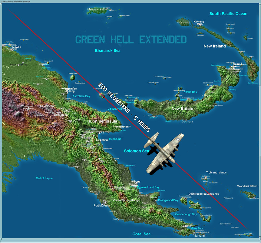
we've been working on our map, considerably extended westward, thus creating a bunch of new airfields, new textures and places of interest.

- Along the coast, it will now be possible to bomb, strafe, recon or dogfight over Saidor, the Madang/Alexischafen area, Hansa Bay, Wewak, Dagua... (Ki-61 Lovers, wait for it : plenty of them prowling upthere)
- Also, the Highlands  landscapes, down the Markham Valley were retextured and worked around. Places like Bena-Bena and Goroka airfields, intensively used by Australian and American cargo airplanes have been added among a plethora of "Emergency Landing Grounds", all of them accurately (at least as much as we could) pin pointed to their exact location... And you might find them useful when your engine quits returning back to base from a mission ; )
Even included is a tiny Navy PBY Blackcats outpost camp on the Sepik River, as reported and photographed in 1943/44 :)

Basically from corner to corner Green Hell now spans up to about 1500 kilometers  ]hello2[ [932 miles - 810 nautical miles] meaning it would roughly take 5 hours for an aircraft at an average cruising speed of 150kt to fly along the diagonal of the map.

Not that we're trying to break a record here, but it will really allow for developing the Papua New-Guinean campaign well into 1944, as allied kept pushing the Japanese Army and Imperial Navy west along the north coast.

To get to that next release, the Nadzab large airstrips complex has still to be developed, with a few other secondary airfields, until then we'll try to post a few screenshots of our new playground during the weekend.

Cheers and stay safe  ]salut[

Yann & Kevin


Logged

Whiskey_Sierra_972

  • Modder
  • member
  • Offline Offline
  • Posts: 6646
  • In memory of my beloved hero: Saburo SAKAI!
Re: GREENHELL 1942 (Eastern New Guinea and New Britain WIP)
« Reply #342 on: September 11, 2020, 11:21:16 AM »

Great!

A very impressive and record map!

Looking forward to see some amazing screens!
Logged

WxTech

  • Modder
  • member
  • Offline Offline
  • Posts: 6065
Re: GREENHELL 1942 (Eastern New Guinea and New Britain WIP)
« Reply #343 on: September 11, 2020, 06:00:39 PM »

I've found that with large maps such as these (and the 1st version already qualified in this respect),  if I use 2048 pixel high cloud textures the image is doubled, as two slightly offset images. Like suffering a slight double vision. I have to go back to 1024 pixel textures to eliminate (or at least greatly minimize) this annoying artifact. I'm running 4.22.2 modact 5.3.

==========

After installing the first Green Hell, which was designed for 1942, the follow-on 1943 version supplied new versions of some airfields, some expanded in extent, others slightly different, and some also positioned differently. But these revised airfields kept the same name, thus effectively overwriting the earlier versions. This results in some notable discrepancies, buggering up the '42 map. Because I'm more interested in the early period, I reverted back the the '42 airfields, which now compromises the follow-on '43 map.

It would have been wise to name the newer A/F textures differently, so as to keep the earlier '42 version completely intact and separate.

And I suspect the same might apply here again, unless all existing fields have remain unchanged from '43.
Logged
Great minds discuss ideas. Average minds discuss events. Small minds discuss people. - Hyman Rickover (but probably predating his use.)

Tokyo Rose

  • member
  • Offline Offline
  • Posts: 42
Re: GREENHELL 1942 (Eastern New Guinea and New Britain WIP)
« Reply #344 on: September 12, 2020, 05:02:46 AM »

Hi guys and thanks for your comments and inputs,

WxTech, well noted and sorry for this inconvenience, we'll make it up so you can eventualy have 2 if not 3 Green Hell maps at different stages of the war, i.e 1942; 1943; 1944.

More on it a bit later and for now a few screenshots of the current WIP.

Wewak airfield and Wewak point


Wewak Point, heavily defended, pounded by the USAAF on an almost everyday basis at some point


Rufes moored on Wirui beach, Wewak


Boram airfield, next to Wewak


Goroka, in the Highlands, notice that Yann has largely improved the textures for the Highlands.


Bena-Bena, a few miles from Goroka


Some Emergency Landing Grounds, there are dozens of them and most are hair-raising to land on, like KeglSugl and Bundy up in the mountains... you never know, they might be your only option apart from a free fall down the jungle :P


Saidor in the making


Alexishafen, north of Madang


The old airstrip of Nubia, disused, but here. New Nubia and Awar, the two main airfields of Hansa Bay are being worked on at this time.

Nubia and Awar, Manam island in the background.


Cheers
Logged

Squashman

  • Modder
  • member
  • Offline Offline
  • Posts: 554
  • No, I am Spartacus
Re: GREENHELL 1942 (Eastern New Guinea and New Britain WIP)
« Reply #345 on: September 12, 2020, 05:31:01 AM »

Absolutely terrific guys - looking forward to the update  ]salut[  ]salut[  ]salut[
Logged

stanislao

  • Modder
  • member
  • Offline Offline
  • Posts: 1598
Re: GREENHELL 1942 (Eastern New Guinea and New Britain WIP)
« Reply #346 on: September 12, 2020, 08:14:10 AM »


 :)   Given that you are doing an excellent and very useful job and I am very grateful to you for that, there is one thing that would be nice to achieve for better realism during take-offs and landings .. the airport runways seen from above are really nice and well structured, unfortunately during taxiing the definition of runways on the ground is very blurry with an unpleasant "muddy pond" effect would it be possible to increase, at least in the central part of the runways, the pixel density of the texture and bring it at least to the density of the surrounding ground? I realize that the blur makes the merger between track and ground less clear but who knows, maybe there is a way ... ;)

Logged

lowfighter

  • member
  • Offline Offline
  • Posts: 115
Re: GREENHELL 1942 (Eastern New Guinea and New Britain WIP)
« Reply #347 on: September 12, 2020, 06:51:34 PM »

Level of detail is really great for certain areas on the map!
Along this line I wonder if the map makers may put some generic (easier to do) native villages on the map, of course not the real number, that would be huge. In fact quite a few generic villages are there on  the stock New Guinea map.

 I think this will make map more realistic and thus add to immersion.
Density of native villages can be appreciated from WW2 maps in the link below.
Villages don't need to have many objects and addition may not take too much time. What do you think?


http://legacy.lib.utexas.edu/maps/ams/new_guinea_500k/index.html


Logged
Pages: 1 ... 26 27 28 [29] 30 31 32 ... 34   Go Up
 

Page created in 0.038 seconds with 24 queries.