I was wondering if there were talented map makers out there who would be interested in doing a map for one of the Eisenhower options that was floated for the Bay of Pigs invasion. It consisted of the taking of the small island south of Cuba which was called Isle of Pines (Isla de Pinos) and which has been called Isle of Youth (Isla de la Juventud) since 1978.
Prior to the Second World War this was the largest "colony" of American ex-patriots in Cuba. Though many if not all were gone by early 1961, there is a good chance there were still many Cubans living there who would have helped the Cuban ex-patriots who were trying to take back Cuba.
I have spoken to many veterans of the Brigade over the years, and there are several who have said the original plan was to set up a government in exile like the Polish and Czechs did in the Second World War. The fact it was a small unit of about 1,500 with minimal air support meant that the option of Isle of Pines was the more logical approach. The government would be established on the island and a time frame of about 48-72 hours was thought to be enough for recognition as a "nation" by the US. In other words, if they would have captured and held the island for two or three days, there was a chance the "Republic" would have been recognized by Western countries at the time, much like Taiwan off the coast of China was in 1949.
I never paid much attention to the talk over the years until I ran across some information online lately. With some "legwork" the map (or maps) could be made for use in either QMB, Single Missions, or even a DCG Campaign.
Per the instructions, here is the information I have:
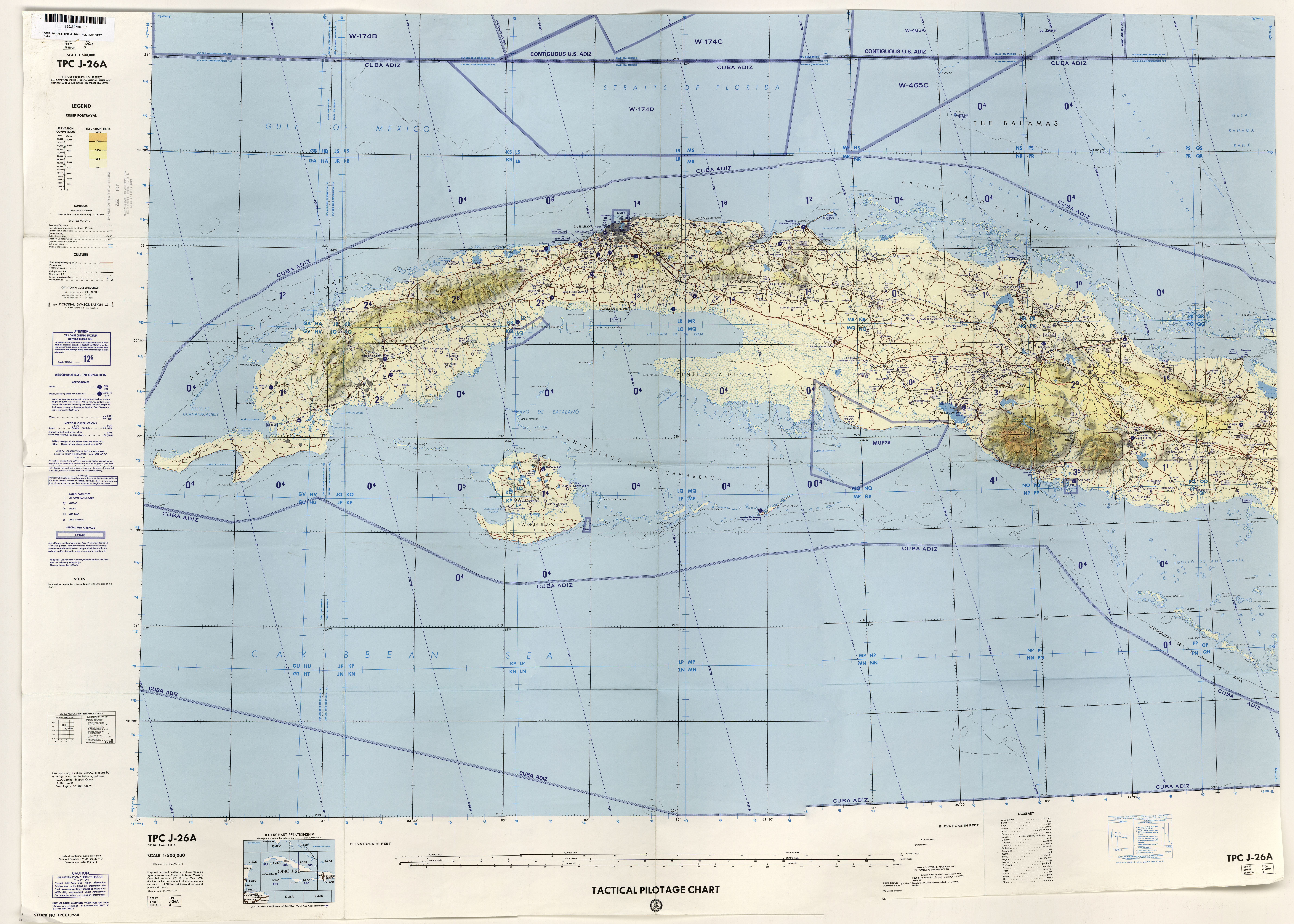
Tactical Pilotage Chart at scale 1:500,000 and labeled with index J-26A, dated with data from 1990 and published in 1991. It would only be for the coastlines and vegitation mostly, but I guess it could be used for population centers and other information as well. Not sure if it would be too big for IL2:1946 since I know maps have to be a certain size.

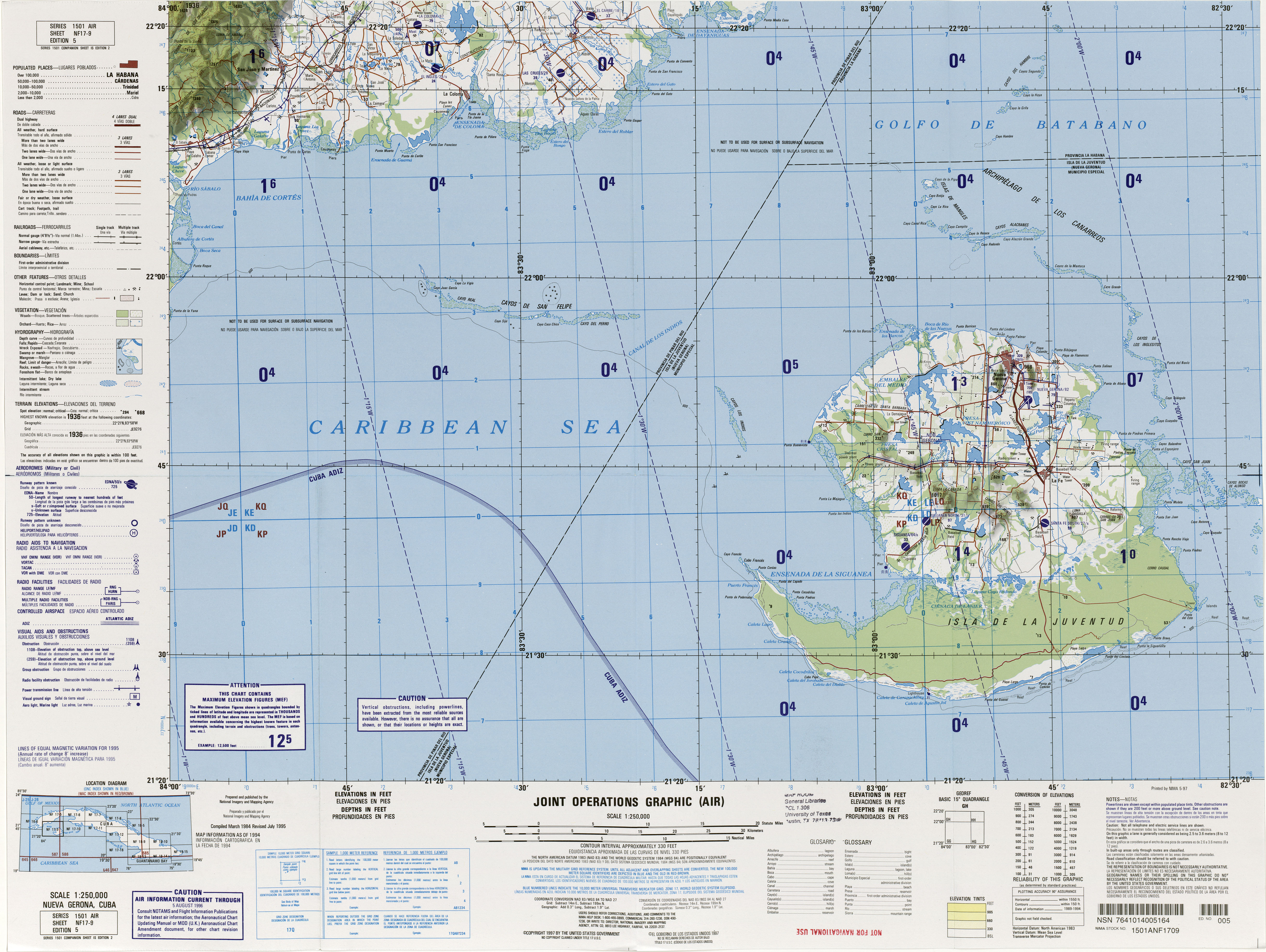
Joint Operations Graphic at scale 1:250,000 and labeled with index NF17-9, dated 1984 and revised in 1995. Same purpose as the one above, but a smaller area covered. It only has a small part of the main Cuban island, so for campaigns there would have to be "off-map" airfields? Fairly new on this, so correct me if I'm wrong.

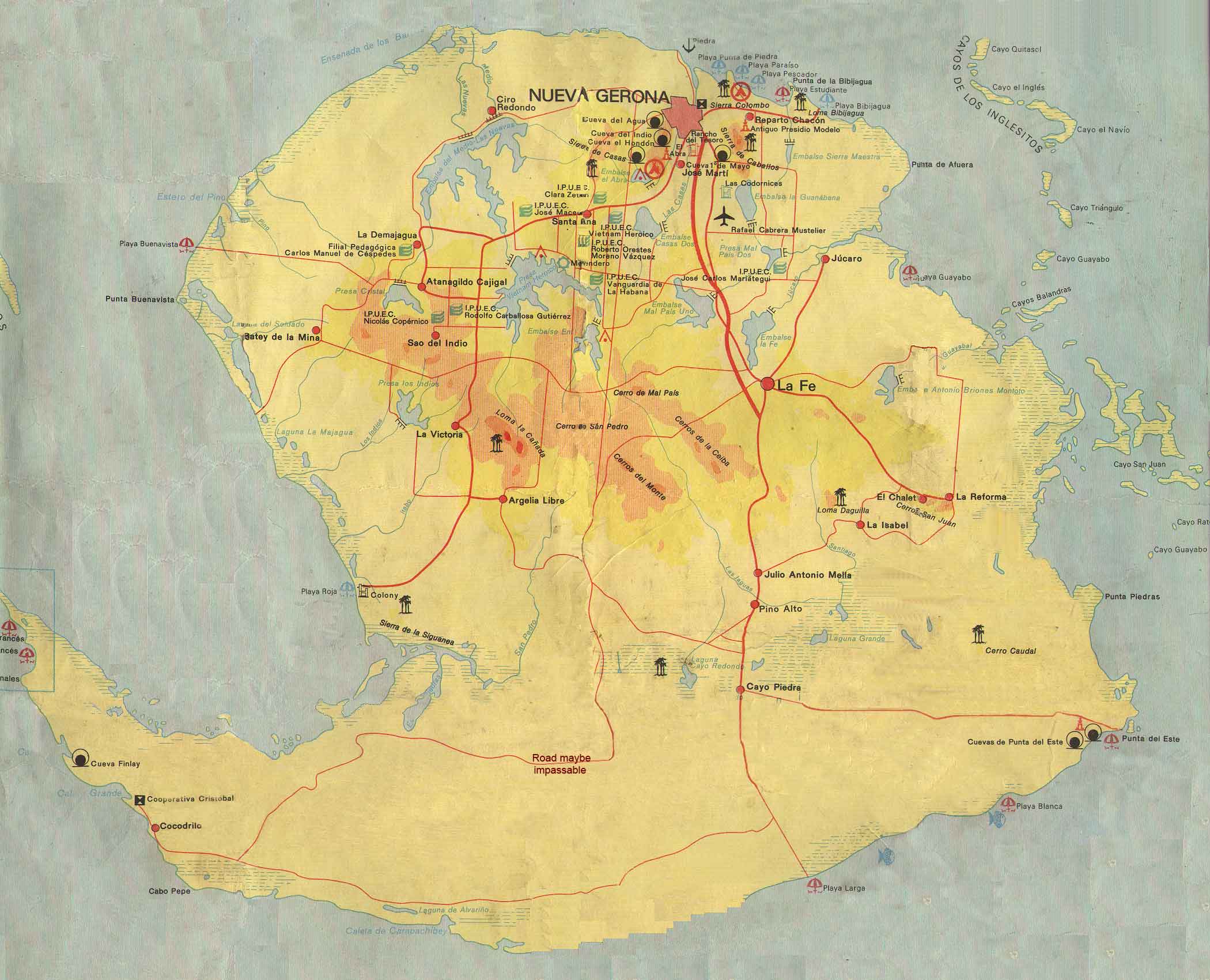
Specifications online regarding the "option" which to an extent corroborates the information I've heard over the many years of knowing some of those who fought with the Brigade. It's located about 3/4 of the way down and has yet another map of the island. Here is the information as well as the extract:
CONOPS COA #2--Free a Part of Cuba

With benefit of 20-20 hindsight, why couldn't Assault Brigade 2506 be given a smaller military task then immediately overthrowing Castro and taking over the Cuban land mass with just 1, 500 men and a dozen planes and a handful of light tanks?

 Why not instead take the island of Juventud (Youth) also known as the Isle of Pines? Once taken, it would become a defacto "Free Cuba" just like Taiwan is to Red China. The farmland there is said to be the best of Cuba, so grow cash crops of tobacco and sugar there. Put casinos and hotels on the island with nightclubs and dancers like old Cuba--but without the corruption. It would be too costly for Castro to invade and re-take the place over, so he might tolerate the Free Cuban island. The anti-Castro free Cuban exiles would have a homeland to call their own. Everyone wins.

Amazingly, I just found out from Newman's book, Oswald and the CIA that the powers-that-be were considering this exact same thing! On page 201 he reveals:

    The minutes of the White House meeting indicate that the Joint Chiefs "saw no problem" with Bissell's request for American troops to train the Cubans. Dulles said that he hoped five hundred Cubans could be finished with their training by "the beginning of November," a prediction possibly meant to fit with Nixon's election schedule. Dulles then added this: "The FRD is acquiring some B-26s. The aircrews for these could be all Cubans. Mr. Bissell then said that it is possible that the initial para-military operations could be successful without any outside help. He pointed out that the first phase would be that of contacting local groups over a period of perhaps several months and in this period no air strikes would be undertaken. The plan would be to supply the local groups by air and also to infiltrate certain Cubans to stiffen local resistance.

    If local resistance is unable to accomplish the mission and the operation should expand, then there may be a requirement for air action. The plan would be to take the Isle of Pines or another small island for an ostensible base for operations of the [less than 1 line not declassified] forces. It is hoped that this may not be needed but we must be prepared for it."

    Bissell added that eleven groups that had potential had been identified in Cuba. "We are in the process of sending radio communications to them at this time," he said! The air attacks were a significant escalation of the U.S. role. At the meeting, no one asked what the military impact of such CIA-backed air attacks would have in Cuba, and what the cost would be if this were discovered by the press.

    In a historic decision remarkably like the one Kennedy would make after his inauguration, Eisenhower gave the go-ahead to proceed in Cuba, with a key condition attached. Eisenhower's decision and his reasoning are preserved in this passage of the minutes:

    The President said that he would go along so long as the Joint Chiefs, Defense, State and the CIA think we have a good chance of being successful.

Therefore, the BIG QUESTION is WHAT HAPPENED TO TAKING THE ISLE OF PINES BETWEEN THE EISENHOWER ADMINISTRATION AND JFK's?

Taking a part of Cuba and holding it--like an island--makes perfect sense for a limited size force like Brigade 2506. What happened to this? Or was JFK only being set-up with a take all of Cuba only option?
and the map:

And the website for more info, but the stuff coded above should be enough:
http://www.combatreform.org/airbornebayofpigs.htmThe only thing I cannot find an image or information for is the hgt files that I've read somewhere are used with a map tutorial to make maps. Here is the link for the place. It is file F17 near Cuba on the map. It pops up when you hover over the location:
http://viewfinderpanoramas.org/Coverage%20map%20viewfinderpanoramas_org3.htmI've used information from there for FS9 before, so I know the site can be trusted and the information in the hgt files has the least amount of "voids" possible.
For general information about the little island, here is the relevant information from Wikipedia:
History

Little is known of the pre-Columbian history of the island, though a cave complex near the Punta del Este beach preserves 235 ancient drawings made by the native population. The island was first sighted by Europeans in 1494 during Christopher Columbus's second voyage to the New World.

Columbus named the island La Evangelista, claiming it for Spain. The island was also known, at various points in its history, as Isla de Cotorras (Isle of Parrots) and Isla de Tesoros (Treasure Island).

Pirate activity in and around the area left its trace in English literature; notably, Treasure Island by Robert Louis Stevenson, and Peter Pan by J. M. Barrie, each drawing on accounts of the island and its native and pirate inhabitants, by reflecting the long dugout canoes that both pirates and the indigenous peoples used, and the American crocodile (Crocodylus acutus).

Following its defeat in the Spanish–American War and the Cuban War of Independence, Spain dropped all claims to Cuba under the terms of the 1898 Treaty of Paris. The Platt Amendment of 1901, which defined Cuba's boundaries for the purposes of U.S. authorities, left the U.S. position on sovereignty over the then Isla de Pinos undetermined. This led to competing claims to the island by the United States and Cuba.[5] In 1907, the U.S. Supreme Court decided, in Pearcy v. Stranahan, that control of the island was a political decision, not a judicial one.[6] In 1916, a pamphlet titled Isle of Pines: American or What? called for the U.S. to annex or purchase the island to settle the issue.[7]

In 1904, Cuba and the United States negotiated and signed the Hay-Quesada Treaty, which recognized Cuba's sovereignty over the island. The U.S. Senate ratified this agreement on March 13, 1925, over the objections of some four hundred United States citizens and companies, who owned or controlled about 95% of the island's land.[8][9][10]

Prior to 1976, the island was part of La Habana Province. With the political and administrative reorganization of Cuban provinces in 1976, the island was given the status of "special municipality".[11]

Fidel Castro presided at a ceremony changing the name of the island from Isla de Pinos to Isla de la Juventud on 3 August 1978.[12] This was the realization of a promise that he had made in 1967, when he said "Let’s call it the Isle of Youth when the youth have done something grand with their work here, when they have revolutionized the natural environment, when they see the fruits of their labor and have revolutionized society here."
and the link if someone wishes to read more:
https://en.wikipedia.org/wiki/Isla_de_la_JuventudMods, if I've forgotten something or not followed the guide please let me know and I'll see what can be done to correct things. I'm fairly new here and have been gone for over a decade from simming with IL2, so please bear with me as I try to get my head wrapped around things.
I understand there is a Cuba map already, but it covers the historical area for the invasion. This would be a larger area that would cover the
actual area as well as one of the areas of
possible action that could have been taken. If anything, it would prove to be an interesting challenge in the #JTW era of B.A.T. since most of the aircraft are available. The only thing is that the Brigade would have to be represented by the US (Postwar) country slot, with a Brigade 2506 "regiment" in the relevant DCG files.
Thanks for the help and any corrections!
Regards,
Jorge
Miami, FL
 Author
Topic: New Map for Original Cuban Invasion Option. (Read 413 times)


