Special Aircraft Service

Please login or register.

Login with username, password and session length
Advanced search  
Pages: [1] 2   Go Down

Author Topic: Questions about my first map  (Read 2145 times)

0 Members and 2 Guests are viewing this topic.

Atoka220

  • Bomber
  • Modder
  • member
  • Offline Offline
  • Posts: 804
Questions about my first map
« on: March 07, 2022, 09:16:59 AM »

Hi

So after reading and learning the basics, I've come to the point of making the 256 color greyscale elevation map using the il-2 colors provided for microdem
Now the tutorial said I need to set the map resolution to 50m/pixel
That resulted in a bmp image not less than 13446x7939 with a file size of 305MB

Is that normal? o_O
The tutorial did mention some huge 19000x14000 map so i suggest yes
It will also be cropped, mostly the western part of it a bit
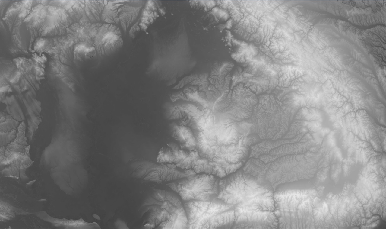
This is it by the way, a map of eastern Hungary and western Romania featuring the Great Plain, North Hungarian Mountains, Transylvania and its mountains and of course the Carpathians
My plan is making a modern version of the Carpathians inspired by Uzin's Carpathians map

Second question:
I've started to draw the rivers by hand for the base of the map_c
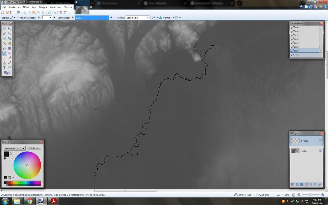
Here you can see I've started drawing the Tisa
I use a line width of 3 pixels as the northern part averages at around 150 meters width
That sounds correct for 50m/pixel resolution
Then it alternates between roughly 190-240m

Then there are thinner rivers such as the Bodrog that I've also started drawing around that mountain where it confluences with the Tisa. That averages between 60-180m
Now if I apply some gaussian blur to make the coast and canyons smoother how much will that affect river width? The Bodrog and such smaller rivers could be in danger of not even showing up in game from what I read

This is my first attempt so any advice is welcome
Logged
There are 2 certain things in life: Death and CTDs

Atoka220

  • Bomber
  • Modder
  • member
  • Offline Offline
  • Posts: 804
Re: Questions about my first map
« Reply #1 on: March 07, 2022, 09:52:08 AM »

Meanwhile another question arose for me

Can we really only use 4 types of textures for everything?
You know these LowLand0-1-2-3 ones
Logged
There are 2 certain things in life: Death and CTDs

WxTech

  • Modder
  • member
  • Offline Offline
  • Posts: 6064
Re: Questions about my first map
« Reply #2 on: March 07, 2022, 12:10:18 PM »

Map_T.tga  and map_h.tga are typically 200m/pixel, while map_c is 50m/pixel.

When fine-tuning coasts and rivers, I'll make a suitably enlarged version of map_h.tga so as to match the scale of map_c.tga in order to layer them together. I'll adjust the transparency of the map_c.tga layer while working on it, so as to best see the topographic features as guides. I've found that if I place a river along the track of lowest elevation, it often needs to be moved (on map_c.tga) a couple pixels left and a couple pixels up in order to more closely follow the valley. It's more crucial in narrow, steep-sided gorges.

To gauge what effects blurring has on rivers, try an experiment with different line widths and differing blur radii. Nothing teaches better than one's own experiments!

Extra layers in map making costs little. And so don't be afraid to dedicate layers to even finely differentiated elements. For instance, you could have separate layers for narrow, medium and wide rivers, which makes it easy to apply filtering specific to each.

As to coastlines, the smallest blur that eliminates stair-stepping is all you need. Unless you are wanting some narrow shallows to be part of the creation. For myself, I prefer to relegate all shallows to its own layer (or layers) during creation.
Logged
Great minds discuss ideas. Average minds discuss events. Small minds discuss people. - Hyman Rickover (but probably predating his use.)

Atoka220

  • Bomber
  • Modder
  • member
  • Offline Offline
  • Posts: 804
Re: Questions about my first map
« Reply #3 on: March 07, 2022, 01:12:48 PM »

So basically there's no written rule, just experimenting
I've come up with an ide to make the tisa wider, say 4 pixels where smaller rivers confluence with it (do i even use this word correctly? lol) so it appears bigger for that part
But later as I progress more south of the river, it does get wider as more and more smaller rivers flow into it. By the time it reaches Serbia I made it 5 pixels wide.
But perhaps I'll find it a bit too thin and actually make the whole thing 4 pixels

About the blur and valleys on map_h, I read through Uzin's method many times and I kinda get a hang of it already. Do you think if it's worth it to make all the map_x files and check it out ingame after I complete a river? (let's say the Tisa in this case? The Tisa has many types of coasts ranging from deep narrow canyons to wide nearly flat valleys. Also I have to consider floodplains. That would be a ton of work to nail but I think it's really worth it (if I want the landscape to be as realistic as possible)
And then there are like 100s of rivers with many lakes and backwaters throughout Eastern Hungary and Romania... I guess I'll leave out the really small ones, so that map_c won't be huge and also a bit less work


Current progress on the Tisa (pun not intended)
At the Ukrainian border I just lost it. It's so curvy and impossible to make out from the greyscale that I can't even find where to look for its traces using satellite photos lol
Logged
There are 2 certain things in life: Death and CTDs

Uzin

  • Modder
  • member
  • Offline Offline
  • Posts: 2816
  • On lifetime holidays
Re: Questions about my first map
« Reply #4 on: March 07, 2022, 01:15:23 PM »

Meanwhile another question arose for me

Can we really only use 4 types of textures for everything?
You know these LowLand0-1-2-3 ones
You can have 24 types of textures regardless of their names which are only conventional.
Logged

Kopfdorfer

  • member
  • Offline Offline
  • Posts: 2177
  • PULVERIZER
Re: Questions about my first map
« Reply #5 on: March 07, 2022, 01:23:56 PM »

Really interesting area to have a map for !
Can you do a simple graphic showing the area you are covering ?
Can you suggest which Cities will be included ?
Very exciting - this area has been needed ( in my opinion ) for a long time.
Best of luck.

Kopfdorfer
Logged

Atoka220

  • Bomber
  • Modder
  • member
  • Offline Offline
  • Posts: 804
Re: Questions about my first map
« Reply #6 on: March 07, 2022, 01:45:11 PM »

You can have 24 types of textures regardless of their names which are only conventional.

Nice
My basic Idea would be to make special textures for cities so to make them look as authentic as possible, but not sure how well I could make that. Or at least put them in until I put the buildings and roads down and then I'll just replace the ground texture with some generic concrete
Creating textures will be the next big wall for me to get a hold on after I'm done with the topo- and hydrography

Kopf, this area has already been made by Uzin

It's basically the Carpathian Basin where there were some significant movements and also a big battle for Debrecen, and one of the biggest tank battles of WW2 on the Hortobágy region, west of Debrecen with also some smaller battles in other cities.
Actually it will still be cropped by a significant amout, like for example I just don't dare to go for Budapest. It's just huge
But then I could also leave it in if I ever get myself into 3d modding to create custom buildings and landmarks so... dilemma

Now my idea is making a modern version with more modern buildings, infrastructure, typical eastern soviet panel blocks, asphalt tunways, etc.
It wouldn't really have anything to do with war, just a modern map. A bit big project for a first one eh? ;D
It's really just to get the hold of it and to be able to fiddle around building cities. I always loved building cities from scratch in FMB as a kid
Logged
There are 2 certain things in life: Death and CTDs

Kopfdorfer

  • member
  • Offline Offline
  • Posts: 2177
  • PULVERIZER
Re: Questions about my first map
« Reply #7 on: March 07, 2022, 04:13:05 PM »

Just my 10 cents worth , but I would put in Budapest to include any local airfields ,
and an approximately correct shape and size and NOT necessarily attempt to
populate it realistically , or at 100% density.
I believe you can give the impression of the city good enough for fighting over
with 1/3 to 1/2 of the required buildings Max.
I know this will garner disagreement from other users - mostly folks who
take still screen shots - but I just fly and fight over them , so I only need the
impression of a city , not every dang building.
AndI want the ability to scan the city with a couple of dozen planes in the air without
it turning into a slide show.

Thanks for your work.

Kopfdorfer
Logged

Atoka220

  • Bomber
  • Modder
  • member
  • Offline Offline
  • Posts: 804
Re: Questions about my first map
« Reply #8 on: March 07, 2022, 05:14:48 PM »

You are right Kopfdorfer
However if this project turns out great, I'll consider making a WW2 version that includes Budapest.
Afterall it saw one of the biggest sieges of World War 2
It would also be neat to maybe make some B-17 and B-24 bombing campaigns as they poured every city of ours but the problem is, they took off from Italy and Africa and that would make a FAR too big map (maybe downscale?). Maybe we could do that from Romania, if not historically accurate, but would get the job done.

On another note, I've decided to check out the topography and the Tisa river that I've completed meanwhile. Guys, I've got it to load on the fist god damn try!
Putting the compass cursor thing on mountains and stuff shows relatively accurate heights. Meanwhile looking at the map, it seems a bit off... Maybe the lack of textures
Here are some screens. I'm not gonna open a WIP thread for it yet as I'm reaaallly far away from actually doing so


Tokaj with the 'Bald mountain' and the confluence of Bodrog and Tisza


Tisza-lake


Carpathians near Brasov


The confluence of Black and White Tisa near Rakhiv, Ukraine not far from the 2 sources of the river

Well yes, the valleys will need a LOT of work

But hey, I'm happy and proud of myself
MY FIRST MAP YAY ;D
Logged
There are 2 certain things in life: Death and CTDs

WxTech

  • Modder
  • member
  • Offline Offline
  • Posts: 6064
Re: Questions about my first map
« Reply #9 on: March 07, 2022, 10:30:06 PM »

Great progress!

Rivers and lakes don't have to be pushed down to zero elevation, unless of course you want the usual bridges to sit properly. (Those bridges placed on terrain higher than zero height will only create a steep-sided hole in the landscape, with the bridge sitting at the bottom.) If you want accurate topography, you can create versions of the bridges which are given a raised height as needed in the static.ini file.

These depressed water features, situated in unrealistic, zero elevation valleys just to accommodate the 'auto bridges', is a long standing weakness of the game engine that hurts my eyes and soul to behold.
Logged
Great minds discuss ideas. Average minds discuss events. Small minds discuss people. - Hyman Rickover (but probably predating his use.)

Atoka220

  • Bomber
  • Modder
  • member
  • Offline Offline
  • Posts: 804
Re: Questions about my first map
« Reply #10 on: March 08, 2022, 06:17:46 AM »

Thanks Glenn

Rivers and lakes don't have to be pushed down to zero elevation, unless of course you want the usual bridges to sit properly.
Yes, I've just learnt that when I checked the map out

I guess I don't have to include the river's line in map_h and then it will follow the natural valley to some extent right? Of course on the Great Plain, It would still happily take some. On the other hand the river's coast is grown in by trees on every single meter except coasts, so It's hard to estimate how wide and steep the real canyons are (well that's the case of almost all rivers on the world)
Guess it will also come down to some experimenting with map_h

Yes, endless questions, but excuse it, it's my first map project afterall ;D
For the bridges, it's also a dilemma for me
Maybe use some bridge objects? Those can be placed at any elevation, just won't be funcional right? Also what about bridges that reach over the river's caynon? Guess auto bridges can't do that
Maybe objects again?

I hope BAT has some pretty bridges for that (and then to find out the height of them heheh)

Update:
Meanwhile I've made a map_h without the riverbed and it does look WAY better up in the mountains wow
The bank and valley just looks so natural

Original map_h


map_h with no riverbed


Although for the plains, I'll keep it on the map_h
And of course the water is full of anomalies (following the terrain and stuff) so I guess I'll work it out in FMB. Its kind of a tideous work but the result is worth it, and the blur tool is just brilliant
Logged
There are 2 certain things in life: Death and CTDs

Atoka220

  • Bomber
  • Modder
  • member
  • Offline Offline
  • Posts: 804
Re: Questions about my first map
« Reply #11 on: March 08, 2022, 03:59:57 PM »

I've finished the rivers

I went for these main rivers as the map_c is already becoming huge lol

Code: [Select]
The rivers (and their tributaries) in the order they confluence with Tisa respective to its direction of flow

Tisza/Tisa/Tysa
Szamos/Someș (Also Great and Little)
Bodrog
Ondava
Latorca/Latorica
Laborc/Laborec
Sajó/Slaná
Hernád/Hornád
Maros/Mureș

Duna/Danube
Olt

Texturing experiment on the Tokaj mountain


Danube-Tisza confluence


Now how does one exactly create a useful map_T?
Also how do I determine where cities and villages are?

And also Uzin mentioned I can use up to 24 textures for something
Now that'd be great if I could use that many for cities, so I could get most look kind of like the real thing

And I also saw that trees are placed using a tree map, putting pixels everywhere I want trees
Well, any tips on that would be welcome
Also can we place and remove those trees one by one by hand in FMB?
Logged
There are 2 certain things in life: Death and CTDs
Pages: [1] 2   Go Up
 

Page created in 0.031 seconds with 25 queries.