Special Aircraft Service

Please login or register.

Login with username, password and session length
Advanced search  
Pages: 1 [2] 3   Go Down

Author Topic: Location of Uzhgorod AF during WWII ?  (Read 1221 times)

0 Members and 4 Guests are viewing this topic.

Piotrek1

  • member
  • Offline Offline
  • Posts: 2344
    • SAS IL BYTES BACK
Re: Location of Uzhgorod AF during WWII ?
« Reply #12 on: September 05, 2023, 03:00:21 PM »

Code: [Select]
I think there were two airfields:

Lemberg-Sknilow (POL/UKR) (e. Lvov-Sknilow; ukr. L’viv-Sknyliv) (49 49 00 N – 23
57 00 E)
General: airfield in former SE Poland (today NW Ukraine); airfield located 6.5 km SW of
Lvov city center. Rated for bombers. History: pre-war airport for LOT Polish Airlines,
base of Polish AF 6th Air Rgt. and home field for Aeroklub Lwowski (Lwów Flying Club).
Frequently mentioned in lists of WW II Lw. airfields in Poland, Sknilow was the Luftwaffe’s

principal airfield at Lemberg (Lvov). Served as an aircraft ferrying station, transient field
and supply hub for much of the Eastern Front after the invasion of the USSR in June 1941.
Surface and Dimensions: grass surface with an extensive artificial drainage system
measuring approx. 1150 x 1050 meters (1260 x 1150 yards). There were 2 runways
(paved?) of 1150 meters aligned NW/SE and NE/SW. Infrastructure: reportedly extensive
with full servicing and support facilities. Dispersal: well-organized dispersals were
available.
Operational Units: 5.(H)/Aufkl.Gr. 21 (Sep 41); KGr. z.b.V. 7 (Feb 42); I./KG 100 (Mar
43); Verbindungskdo. (S) 4 (Sep-Oct 43); Schleppgruppe 2 (Oct 43 – Apr 44); I./SG 77
(Oct-Nov 43); II., III./KG 27 (Jan-Mar 44); 2.(F)/Aufkl.Gr. 100 (Feb-Mar 44); 2.
(F)/Aufkl.Gr. 11 (Mar 44); III./JG 52 (Mar-Apr 44); Stab/NAGr. 6 (Mar-Jun 44); Stab, I./KG
27 (Mar 44); 14.(Eis)/KG 27 (Mar 44); IV./TG 1 (Mar-Apr 44); part of IV.(Pz)/SG 9 (MarApr 44); 2./NAGr. 2 (Mar-Jul 44); III./SG 77 (Mar-May 44); Stab/SG 77 (Mar-Jun 44); 10.
(Pz)/SG 77 (Mar-Jun 44); II./SG 77 (Mar-Jul 44); IV./JG 54 (Apr 44); Transportstaffel VIII.
Fliegerkorps (Apr-May 44)?; Stab/NAGr. 2 (May-Jul 44); 7.(H)/Aufkl.Gr. 32 (Jul 44).
Station Commands: Fl.H.Kdtr. A Lemberg (8 Sep 41); Fl.H.Kdtr. A(o) 102/VIII (Apr – Jul
44).
Kommandant: Obstlt. Hans-Nikolaus von Beguelin (Aug 43 - ? ).
Station Units (on various dates – not complete): elements of Feldwerftverband 40 (Jul
42); elements of le.II/Feldwerftverband 20 (Apr 44); le.Feldwerft-Abt. I/70 (May 44);
Wintersondergerätezug 33 (Oct 43 - ?); le.Flak-Abt. 81 (Mar 44). Also see above under
Lemberg – Lw. Garrison.
[Sources: AFHRA A5263 p.1114 (31 Dec 43 updated to 30 Jun 44); chronologies; BA-MA;
NARA; PRO/NA; web site ww2.dk]

Lemberg-Winniki (POL) (a.k.a. Vynnyky) (c. 49 48 30 N – 24 08 20 E)
General: emergency landing ground (Notlandeplatz) in SE Poland 8.5 km ESE of Lemberg
(Lvov) city center. History: no wartime details found.
[Sources: AFHRA A5263 p.1115 (31 Dec 43 updated to 30 Jun 44); chronologies; BA-MA;
NARA; PRO/NA; web site ww2.dk]

Edit:

Lemberg-Sknilow (POL/UKR) (e. Lvov-Sknilow; ukr. L'viv-Sknyliv) (49 49 00 N - 23
57 00 E)

Lemberg-Winniki (POL) (a.k.a. Vynnyky) (approx. 49 48 30 N - 24 08 20 E)
General: emergency airstrip (Notlandeplatz) in south-eastern Poland, 8.5 km east of the centre of Lviv.
(Lviv). History: no wartime details found.
[Sources: AFHRA A5263 p.1115 (31.12.43 updated to 30.06.44); chronologies; BA-MA;
NARA; PRO/NA; website ww2.dk]

I accidentally posted Lida too
Logged

SAS~Loku

  • SAS Team
  • member
  • Offline Offline
  • Posts: 662
Re: Location of Uzhgorod AF during WWII ?
« Reply #13 on: September 05, 2023, 05:47:28 PM »

Try this: http://maps.mapywig.org/m/WIG_maps/series/500K_pre-WW2/MPIKO_500K_M-34-IV_PRZEMYSL_WT_1939.jpg
This hi-res scan of the map show all three citys: Krosno, Lwów\Lviw, Uzhgorod and their airfields marked with red dots (bottom of the map has a description for them)

Here is link to the main site with more maps.
http://igrek.amzp.pl/mapindex.php?cat=WIG500E1&listtype=standard&listsort=sortoption1
Logged
P7a/P11c/f/g P24a/b/e/f/g PZL23/42 PWS-10/26 R-XIII RWD-10/14 GeeBeeR1/R2/Granville P-45 , WhippetMkI, Sdkfz-234/1/2, Kurogane, TKS, Wz.29/34 and some other shit XD

Piotrek1

  • member
  • Offline Offline
  • Posts: 2344
    • SAS IL BYTES BACK
Re: Location of Uzhgorod AF during WWII ?
« Reply #14 on: September 06, 2023, 02:06:54 PM »

Returning to the missing towns on the map, the following towns are missing:
  Jedlicze (an oil refinery operated there during the war, as well as today)
Dukla,
large villages of Moderówka, Równe, Głowienka, Kobylany
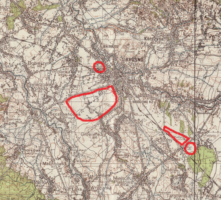
and two alternate airfields Krosno-Łężany and Krosno-Moderówka,
(On the map below you can clearly see the outlines of Krosno airport on the outskirts of the city )
maybe this piece of map of the region will help ?(map i can send you):


Best regards,
Piotrek
Logged

Uzin

  • Modder
  • member
  • Offline Offline
  • Posts: 2816
  • On lifetime holidays
Re: Location of Uzhgorod AF during WWII ?
« Reply #15 on: September 07, 2023, 09:38:44 AM »

Thanks forsupport.
Just some notes:
1. Dukla is present on default Il2 map.
2. My old eyes cannot recognize AF near outskirts of Krosno at your picture of the map. Can you give an arrow somewhere there, please?
3.How about true height of Carpathian mountains? The map seems too flat.
E.g. mt. Berdo is 1197 m high, Stara Schebela 1216 m, Parashka 1268 m, Tarnica 1346 m.
 At Polonina Runa true height is 1480 m,   while it shows only 510 m in Il2 Lvov default map.
Logged

Piotrek1

  • member
  • Offline Offline
  • Posts: 2344
    • SAS IL BYTES BACK
Re: Location of Uzhgorod AF during WWII ?
« Reply #16 on: September 07, 2023, 12:01:40 PM »

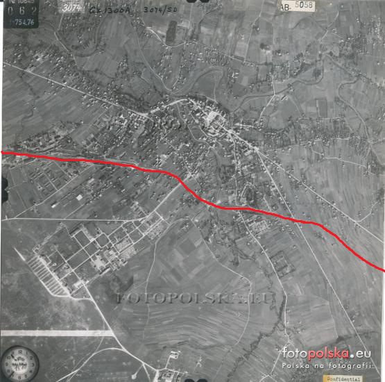
Based on the readings from the map and the route of the railway and after comparing them with aerial photographs from 1944 I marked more or less the shape of the Krosno airfield and the reserve airfield in Łęzany, and the location of the refineries in Krosno and Łężany with a red circle:
Krosno 1944:

Airfield  Krosno-Iwonicz (POL) (a.k.a. Krosno-Łęzany):
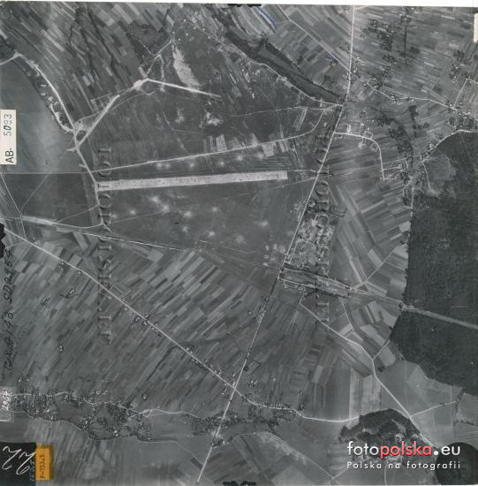
Krosno-Iwonicz (POL) (a.k.a. Krosno-Łęzany) (49 39 40 N – 21 49 30 E)
General: landing ground in S Poland 170 km SE of Kraków and 5 km SE of Krosno.
History: built 1937-38 and used as a satellite of Krosno (Altkirch). Surface and
Dimensions: grass surface measuring approx. 1190 x 730 meters (1300 x800 yards). The
1190 meter (1300 yard) runway (paved?) was aligned NW/SE. Infrastructure: limited
facilities but had dispersal areas for aircraft.
Remarks:
26 Aug 44: mines had been detonated on the landing area by this date rendering it
unserviceable.
Operational Units: III./KG 51 (Jun-Jul 41); Stab, III./SG 10 (Jul 44).
Station Commands: Fl.H.Kdtr. E 10/VI (Mar 44)?; Fl.H.Kdtr. E(v) 208/VIII Krosno-Lezany
(Apr-Sep 44).
Station Units (on various dates – not complete): none identified.
[Sources: AFHRA A5263 p.1110 (31 Dec 43 updated to 26 Aug 44); chronologies; BA-MA;
NARA; PRO/NA; web site ww2.dk]

As for the hills in my area (Beskid Niski) they are 500-600 to 700 metres each.


Logged

Uzin

  • Modder
  • member
  • Offline Offline
  • Posts: 2816
  • On lifetime holidays
Re: Location of Uzhgorod AF during WWII ?
« Reply #17 on: September 07, 2023, 01:21:03 PM »

Many thanks !
Logged

Piotrek1

  • member
  • Offline Offline
  • Posts: 2344
    • SAS IL BYTES BACK
Re: Location of Uzhgorod AF during WWII ?
« Reply #18 on: September 07, 2023, 01:46:45 PM »

I am glad that I could help, I would also point out the approximate location of the Moderówka airfield, but unfortunately this village is not on this map,
I also have a couple of photos of the Krosno airfield in various shots, should they be needed.

Best regards,
Piotrek
Logged

Uzin

  • Modder
  • member
  • Offline Offline
  • Posts: 2816
  • On lifetime holidays
Re: Location of Uzhgorod AF during WWII ?
« Reply #19 on: September 07, 2023, 01:54:05 PM »

The more historical infos being available the more nice will be the corrected map.
By the way, I decided not to elevate the terrain to its real value, since than the default bridges can be left as they are, i.e. at zero level height.
Logged

Piotrek1

  • member
  • Offline Offline
  • Posts: 2344
    • SAS IL BYTES BACK
Re: Location of Uzhgorod AF during WWII ?
« Reply #20 on: September 07, 2023, 02:12:48 PM »

I actually thought I had more pictures :-[, hopefully they will be useful in some way:
https://drive.google.com/file/d/1aWupdxONlX4IuUkRAtrXLCtmt75nX6gN/view?usp=sharing

Best regards,
Piotrek
Logged

Piotrek1

  • member
  • Offline Offline
  • Posts: 2344
    • SAS IL BYTES BACK
Re: Location of Uzhgorod AF during WWII ?
« Reply #21 on: September 08, 2023, 01:09:06 PM »

Just some notes:
1. Dukla is present on default Il2 map.
Apparently there is some other map in the Vp modpack because Dukla is not there.
Logged

Uzin

  • Modder
  • member
  • Offline Offline
  • Posts: 2816
  • On lifetime holidays
Re: Location of Uzhgorod AF during WWII ?
« Reply #22 on: September 08, 2023, 04:41:22 PM »

Just some notes:
1. Dukla is present on default Il2 map.
Apparently there is some other map in the Vp modpack because Dukla is not there.
My mistake, sorry.
 Dukla added now, south from Leki dukielske.

EDIT:
Those added in between Uzhgorod and Peretchyn:

Vorochovo
Kamianytsia
Onokivtsi
Logged

Piotrek1

  • member
  • Offline Offline
  • Posts: 2344
    • SAS IL BYTES BACK
Re: Location of Uzhgorod AF during WWII ?
« Reply #23 on: September 09, 2023, 05:37:40 AM »

Hi Uzin,
Thank you for keeping us familiar with the updates on a regular basis 8), for me it is a very interesting map although I very much regret that nothing can be done about the terrain, in some places on the map it does not coincide with reality at all :-X.

Best regards,
Piotrek
Logged
Pages: 1 [2] 3   Go Up
 

Page created in 0.031 seconds with 24 queries.